Showing posts with label SW 136 Street Project. Show all posts

Saturday, March 19, 2022

Marlin Engineering provides guidance on a proper shared path. This is important for Coral Reef Drive & 184 – and the specifications demonstrate that the 136th Shared Path is more a mess than a safe path – important details.

Do it right, or don't do it at all. The current mayor and this council should not repeat the mistakes made in redesigning the SW 136th Street project. The photos at the bottom serve to shine light on poor planning and defines the term forcing a square peg in a round hole - who is really happy with SW 136th Street? The results really do not fit in this particular place or situation. 

Important point: There is no legal requirement to make profound changes to either SW 184 or Coral Reef Drive - so the Palmetto Bay mayor and council should resist temptation to spend the tax dollars, unless the project brings quality improvements to those streets. Don't sacrifice historic coral rock walls and magnificent shade and clean air producing canopy trees to a vanity project.

The first question is whether a shared path properly fit in the existing street right of way.  This Coral Reef / 184 project is not one of a pre-planned area. These areas will require significant work arounds due to many existing obstacles such as power poles, coral rock walls and many, many historic trees. Marlin Engineering* has provided recommended specifications regarding a proper shared path (see figure and description posted below). This is important for Coral Reef Drive & 184 – and the specifications demonstrate that the 136th Shared Path is more a mess than a safe path – important details.

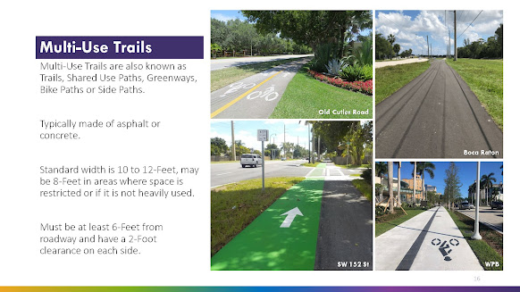
The following is the Marlin Engineering planner's specifications contained in slide 16.

  • The standard width is 10 to 12-Feet, may be 8-Feet in areas where space is restricted or if it is not heavily used.
  • The path must be at least 6-Feet from roadway and have a 2-Foot clearance on each side.

See Page/slide 16 of the Multi-Use Trail & SMART Plan Connectivity Study, Bicycle & Pedestrian Advisory Committee Meeting, November 16, 2021

Why is the above important?

Because here are some photos taken of the SW 136th Street path where you can clearly see significant portions of the path where these important guidelines are not met:


Observable issues (above). The path at these points are neither 6 feet from the roadway nor is there the stated recommended two feet clearance on the other side (backs up to a thick hedge - you can see why that would be a problem when dealing with handlebars, etc.)

Immediately above and below - there is no explaining splitting the path into two separate 4 foot sections. Does it really equal a useable 8 feet? Is the sidewalk traffic really that bad that Palmetto Bay officials feel the need to created a divided pathway to separate oncoming users? There is no 2 foot buffer to the inside portion as well as a lack of 6 feet buffer from the street. The only way to describe this is the useable swale area (water runoff) and resident/guest parking is gone, essentially the entire right of way has been paved over.


Above - twisting and turning with an abrupt reduction from 6-8 feet to a standard 5 foot sidewalk, clearly not within the Marlin Engineering guideline.

Below - where is the safety buffer from traffic? Cars can and will easily pull off the road and onto the pathway, placing users at risk.

CLICK HERE to view prior related posts on shared paths including 136th Street, Red Road and Old Cutler Road, both in Palmetto Bay as well as in Cutler Bay.

*Marlin Engineering is facilitating Palmetto Bay's Multi-Use Trail & SMART Plan Connectivity Study

Sunday, October 24, 2021

Special post - Video of the day. The Old Cutler Trail: a shared path. Would you walk or ride through a loading zone? No. But then why would you use a shared path as an unloading zone? Is there any enforcement?

Another day, another violation on a shared path in Palmetto Bay. This is a safety issue.

I ask you, would you allow children to walk or ride bikes and scooters around trucks in a loading zone? Of course not. Then why would you allow multi-paths to be used as a parking/unloading zone, especially at a time and on a day when you expect children to be riding this shared path?
This is yet another example as to why I fight for bike lanes, not shared paths. Multi-paths are too easily misused by vehicles for either parking or even driving. And please, I've heard that I should call the police, not post on social media. Not buying that. I'm out riding, not patrolling. We have police patrolling. In my opinion, this is a clear and obvious violation of the multi-path (no motorized vehicles) as well as an affront to the ADA. You want shared paths? Then enforce rules that make paths safe. It is not up to cyclists to police the paths like a pack of 'boomer Karens'. The SW 136th Street Path is not even complete and already … it’s a parking space! Seen on SW 136th Street on Friday, October 1st, 2021. Hey, Sue, I guess the cyclists have more room in the lane when the cars 'take the path'! See: October 2, 2021, Special post - Photo(s) of the day. Reader submitted photos of the Palmetto Bay designed shared path. Or is it a car park?

Wednesday, October 20, 2021

Sat 10-16-21 Update on 136th Street Shared Path - take the virtual ride via 3 videos that demonstrate the status of this project

Video I (3 minutes, 54 seconds)- starting he journey from the furthest point currently paved west end - moving east 


 Video II (3 minutes, 3 seconds)- Moving eastward from 77th Avenue:


Can one ride a bicycle on the existing standard sidewalk, aka, was it really necessary to spend $1.8 million to widen the existing sidewalk from the standard 5 feet to 5, 6, 8 or 10 feet in odd areas? Let's find out in video III.

Video III - (52 seconds) riding the existing standard size sidewalk that remains (for now) eastward to the end at Old Cutler Road:


PRIOR RELATED POSTS on Shared Path Comparison - the Red Road Linear Path in Pinecrest as well as the Cutler Bay Shared Path. 

Monday, October 18, 2021

UPDATE: Series on Multi Paths - looking at the Red Road Linear Park Path. How it compares to the Palmetto Bay designed 136th Street project.

This video is part of a series examining multi use paths in our area. I plan in comparing the Old Cutler Trail, the Cutler Bay Shared use path, the Pinecrest Red Road Lineal Park Path. All compared with the current Palmetto Bay designed Shared Path now under construction on SW 136th Street. 

Many of you may be familiar with this Red Road Linear Park Path. It was originally created under Miami-Dade County and later nurtured and maintained by the Village of Pinecrest. Compare it with the JPA shared path that Palmetto Bay designed for SW 136th Street.

The Red Road Linear Park Path is a 2.5 mile lighted walking/bicycle path along the Snapper Creek Canal on Red Road. There are three rest areas accented with coral rock walls and enhanced landscaping along historic Red Road, located along the East-side of Red Road between Kendall Drive and Killian Drive in Pinecrest, Florida.

Now this is a shaded, park type amenity that provides safe mobility!

Here is a Yelp Review of this path/park:

Yes, per the Village of Pinecrest, this does qualify as parkland. It's a little strip of land bordered by Red Road on one side and the Snapper Creek Canal on the other. There is a meandering paved path, one upon which my running feet pound quite often. It's a running/walking/biking/blading path, and a good one.

The park is listed as 2.5 miles long. I'm surprised at that, because my internal odometer says it feels a little less. Maybe that's because unlike many other South Florida "parks," it actually has a bit of a tree canopy, helping somewhat to ease the pain the sun brings. In fact, there's a wide variety of native plant life on display along this path, from gumbo limbo to cypress to pond apple. This helps make the path as scenic as a path that close to a busy road can be.

This stretch of Snapper Creek looks like an enticing place to cast a fishing line, but in all honesty, the fishing here sucks. This stretch of the canal is just a deep featureless ditch, with little or no aquatic plant life or other structure providing cover for fish.

Insider tip....only run here when the wind is out of the east, the path is on the east side of Red Road. Run here during periods of westerly breeze, and you open yourself up to breathing truck exhaust.

Important note - this is one multi use path where there are no potential conflicts with motor vehicles - not one. At no point do vehicles cross the path at any point along any of this 2.5 mile path.

Take note of the following for this Red Road Linear Park Path:

  • The appearance of park amenity including numerous park type benches. The uniformity of the path.
  • The quality of the construction.
  • There are no areas of conflict with cars anywhere along the entirety of the 2.5 miles of this path. It is a path uninterrupted by any conflict from motor vehicles crossing the path. 
  • At no time does this path narrow from its uniform width, nor does it take any sharp turns or curves (once it begins – the southern terminus connects to the cross walk that leads to Pinecrest Gardens – and other path. 

Contrast this with the Palmetto Bay designed shared path. Note that there will be as many as 70 separate areas of conflict with roadways and the numerous driveways that will cross the Palmetto Bay designed shared path along SW 136th Street. And note, I have previously identified that safety is compromised at each point where motorized vehicles cross shared paths. 

See PRIOR RELATED POST of September 29, 2021, Series on Multi Paths - looking at Cutler Bay's shared path project. How it compares to the Palmetto Bay designed 136th Street project.

Wednesday, October 13, 2021

Small bite update: Why are cyclists still riding on the road, not the path along SW 136 Street

I received the following text from a teacher at Howard Drive Elementary yesterday (October 12, 2021):

“Two days in a row I have seen people biking on the road instead of the new path.”

I answered that cyclists will remain using the road as they do on Old Cutler Road and Red Road. A shared path is not a bike lane. In Florida the bicycle is defined as a vehicle and the bicyclist is a driver. Bicyclists have the same rights to the road ways. HOWEVER, bicyclists must use a bike lane where provided (subject to certain exceptions).

Her response was in the form of an emoji. It was very telling as well as amusing (emojis can be so revealing - and saved so many words):


See: July 8, 2021, Cycling/Rules of the Road update: Changes in Florida Law that impact Motor Vehicles / Bicyclists effective July 1, 2021. This article is an update of a Rules of the Road post of November 28, 2018.

The bottom line is that there will be little change for the cyclists. It is the motorist who lost out when the bike lane plan was changed to the shared path. Get used to SW 136 Street working as depicted in the photo.  And please don't yell at the cyclist for remaining on the road and not using the path as they are doing what was intended, recommended actually by at least one of mayor Cunningham's advisers to the 136 Street shared path project. 

Also see PRIOR RELEVANT POSTS:

June 22, 2021, Palmetto Bay can change the project, but municipal officials cannot change State Law which determines where bicyclists may ride.

October 2, 2021, Special post - Photo(s) of the day. Reader submitted photos of the Palmetto Bay designed shared path. Or is it a car park? 

June 24, 2020, Yet another car v bike conflict along the Old Cutler Trail – a multi-use path, not a dedicated bike lane.

Saturday, October 2, 2021

Special post - Photo(s) of the day. Reader submitted photos of the Palmetto Bay designed shared path. Or is it a car park?

Part I - This is just plain funny. You have to laugh or we will all end up crying. This split of the path is not on the plans. This is an off plans modification. The question is whether two 5 foot sections really function as a 10 foot shared path when it is split in two and have trees placed in the median? Is this a Palmetto Bay designed landscaped median for a divided walkway? [Editor's note - these photos were sent by a reader (FOSDU) who asked to remain anonymous.

Does this look familiar? Like maybe the same treatment that killed the oak at Coral Reef Park?

The contributor provided the following comments with the photos:

Coral Reef Park - it killed this tree

This tree might not survive because the root was pruned back to the trunk.  The 10 foot sidewalk is now a double sidewalk and unsafe close to the road. Perfect situation for injury.

Who dreams this stuff up?

Editor's opinion: Who dreams this up? The current mayor and 2 additional village council members who voted (3-2) to change the plans from bike lanes to this shared path. See: June 28, 2021, The smoking gun: April 6, 2019, the day the current mayor and the 2019 council voted to change the bike lane plan to shared path by a narrow 3 – 2 vote. Now they are coming for the mature trees

Is this another Palmetto Bay project that will result in stressing and killing yet more trees here in a Tree City USA Community? see September 12, 2021, Why? These trees once thrived in Coral Reef Park. That is until this current mayor and council started their war on trees in Palmetto Bay 

This is one of those truth is stranger than fiction / you can make this stuff up. I have to ask Sue (you know who you are), do you really think that this path will properly function as a shared path - for bike mobility? See Part II, below, for some cold water in the face reality as to the real uses for this shared path.

Seriously Sue, you are against bike lanes, as cycling groups would have to ride within the bike lanes where provided and, as you say, they (cycling groups) would rather take the lane. That is incredibly selfish.

Part II - That sure didn’t take long. The path is not even completed and already … it’s a parking space! Seen on SW 136th Street on Friday, October 1st, 2021. Hey, Sue, I guess the cyclists have more room in the lane when the cars 'take the path'!


Note the cyclist, who is STILL making proper use of taking the lane. (This cyclist is riding properly - riding a legally intended on this road.)

Thursday, September 30, 2021

"Missed message": Ignoring Cortada’s message as the current mayor once again misses the importance of going native – a Wildflower Meadow could have been planted, but we get – instead - another wasteful grass lawn

Pallets of sod on 136 Street
What a wasted opportunity! And this is what happens when you leave out creative minds and input from those concerned with the environment.

Truly a missed opportunity. Palmetto Bay could have — no, should have —planted for pollinators and established a Wildflower Meadow habitat for our local birds, bees and butterflies. But this takes thought, and concern for our environment. Once again, this project was never brought out for a public discussion. No public disclosure of the alleged landscaping plan.

Instead, sod was delivered to the SW 136th Street MEGA sidewalk Shared Path project on Wed. 9/29/2021. Please tell me that this is a joke, that SW 136 street is not actually receiving a planting of non-native grass as the replanting of greenspace lost to the MEGA sidewalk. 

This is not an environmentally friendly landscaping plan. Instead, it is a waste of lawn that will require fertilizer and watering - something that a village should avoid if it truly wants to be green. 

Instead, this mayor and council missed the message put out by the recent art piece installed by local artist Xavier Cortada - the message of Cortada's  "Flower Force" public art sculpture should have inspired this mayor and council to follow the LEED /sustainability statement and plant native Coreopsis wildflowers (the official State of Florida wildflower) rather than a high maintenance lawn. The native coreopsis wildflower is a Florida native. It is no maintenance and drought tolerant.

What a loss. A Wildflower Meadow might have improved this bland cement mega sidewalk. Seriously, what would have looked nicer, a Wildflower Meadow or grass? Another opportunity to improve our native environment is lost. We could have involved our local students in a planting project. Bringing volunteerism back to Palmetto Bay and continued to develop a sense of environmental steward ship, but instead, opportunity lost.

A wildflower meadow may have really tied SW 13th Street together.
It certainly would have been nicer than plain high maintenance St. Augustine lawn!

Oh, and just an aside, small landscaping trees are currently being planted. I have two observations here: First that these trees are small, not making up for the canopy of the mature trees lost to the cementing of SW 136 Street. Secondly, these trees are being planted on the Pinecrest side.

Yes, that's right, Pinecrest gets more trees and green while Palmetto Bay gets cemented over.

But then again, this mayor and council proceeded on this project on their own without public input or input from the Tree Board or Palmetto Bay Garden Club. The Palmetto Bay Garden Club would have been an excellent resource both for sustainability as well as creativity. 

Wednesday, September 29, 2021

Series on Multi Paths - looking at Cutler Bay's shared path project. How it compares to the Palmetto Bay designed 136th Street project.


This video is part of a series examining multi use paths in our area. I plan in comparing the Old Cutler Trail, the Cutler Bay Shared use path, the Pinecrest Red Road Lineal Park Path, all with the current Palmetto Bay designed Shared Path now under construction on SW 136th Street. 

Part 1. Please look at this shared use path that Cutler Bay worked on with Miami-Dade County and compare it with the JPA shared path that Palmetto Bay designed for SW 136th Street.

Take note of the following for this Cutler Bay designed shared path:
  • The appearance of park amenity including numerous park type benches. The uniformity of the path.
  • The quality of the construction.
  • There are minimal areas of conflict with cars - in fact, there are no conflicts in the first 1 minute, 46 seconds of this video. The distance is .4 of a mile or 2,116 feet (measured via Google Earth) where there is a path uninterrupted by any conflict from motor vehicles crossing the path. 
  • There are a total of 17 areas of potential conflict (after the .4 mile area mentioned above). There are few streets; most are business driveways all located in close proximity to the Franjo Road business district.
  • At no time does this path narrow from its uniform width, nor does it take any sharp turns or curves. 
Contrast this with the Palmetto Bay designed shared path. Note that there will be as many as 70 separate areas of conflict with roadways and the numerous driveways that will cross the Palmetto Bay designed shared path along SW 136th Street. And note, I have previously identified that safety is compromised at each point where motorized vehicles cross shared paths. 
Above and below, photos depicting the construction status of the Palmetto Bay designed shared path on SW 136th Street. Some landscaping will eventually be restored, but the widths will not change. The first photo shows a full 10 foot section that reduces to an 8 foot wide section. The other photo above shows a section where 8 feet is suddenly reduced to a mere 5 feet (standard sidewalk width). The photo below documents a section "separated" by mere feet and no curbing from SW 136th Street.

Please also note that there was no public input on the Palmetto Bay designed shared path. Not a single public meeting. The re-design was developed in private by a few people with special influence and who enjoy special access to the current mayor.
Reference materials. See prior related posts of:


And yes, in the interest of full disclosure, I am a cyclist and I am quite disappointed that this Palmetto Bay designed shared path will not get the cyclists off the road - that would require designation bike lanes - once designed for this SW 136th Street. See: June 22, 2021, Palmetto Bay can change the project, but municipal officials cannot change State Law which determines where bicyclists may ride. 

In other words, drivers will still be required to share SW 136th Street with cyclists. Please don't yell at the cyclists to move off the road. The fault is that of the current Palmetto Bay mayor and council who changed the plans from dedicated bike lanes to a shared path.

Wednesday, September 8, 2021

The Palmetto Bay designed shared path. This project will define the differences between Pinecrest (Green) and Palmetto Bay (from Blue to concrete). Let’s take a look (Part 1 of 3 planned)

The SW 136th Street shared path is essentially an inharmonious collection of varying sidewalk sections cobbled together claiming to be a park amenity. It’s not a cycling amenity as even a few of the current’s mayor’s informal project advisers has been honest that the cycling groups will continue to ‘take the lane’ (use the street, not the path – as is their legal right).

SW 136 Street – a Street that bears stark contrasts between the sides – dividing North from South. 

First impressions are important. 136th Street is the gate way to their Palmetto Bay homes for many. Our community has invested in gateway signage (LED/solar powered, BTW) as well as our signature Palmetto Bay blue street signs. Times change with a new direction now taking shape that will define the differences between Palmetto Bay from Pinecrest when driving down SW 136 Street. Previously the only differences appeared to be green signature signage defining Pinecrest while Palmetto Bay has its ‘Palmetto Bay blue’ signature street signs. 

Palmetto Bay residents obviously bear the brunt of the shared path as it is located entirely on the Palmetto Bay side of the road. Some residents of Palmetto Bay have a 10 foot section adjacent to their property while others have 8 feet or less. Surprisingly, there is a section where the 10 foot section abruptly chokes down to the standard 5 foot sidewalk length.  Many hold the opinion that this shared path is shoehorned into an area that is much too small. It is important to note that there was standard 5 foot sidewalk on this side of the road that predated this path project where many differing users had been long able to walk, jog, and, yes, even ride their bicycles for those who choose to ride on the sidewalk. It was removed in order to create this shared path, along with many mature specimen trees.

Pinecrest residents must be breathing a heavy sigh of relief as their council members invested $1.2 million into this path and some feel as it was money well spent – as the money was well spent to ensure this concrete monster would not tear through Pinecrest’s green space by placing it entirely on the Palmetto Bay side. The Pinecrest side of SW 136 Street remains lushly landscaped, not having lost a single mature specimen tree. There is a standard size sidewalk on the Pinecrest side, where many differing users have been long able, as well as remain able, to walk, jog, and, yes, even ride their bicycles for those who choose to ride on the sidewalk. This is the green side of the road as opposed to the concrete found on the opposing side of the municipal border.

Below: the official project rendering that the Village of Palmetto Bay has posted on its official website - something that most rely upon as a true representation of how this project will appear upon completion.

Two important items to take note of: 
1. The rendering makes it appear as if Palmetto Bay may actually end up with larger, more lush trees over what is portrayed for the Pinecrest side (which is FALSE). 
2. Also note that neither tree appears to be close to the end of the road - there are standards as to where trees should/can be planted near roadways.

Based upon the photos immediately above, I fear whether all residents who live alongside SW 136th Street are being treated equal. Some have 8 foot sections while others have the full 10 feet! At least one homeowner had the shared path reduced to the standard size sidewalk in front of the home (many people are interested to hear how that came about).

FAIR QUESTIONS:
  • What difference does the additional 2 feet serve when so many other sections are set at 8 feet or less, including at least one section where the standard 5 foot wide was reinstalled?
  • Where are the trees going to be planted for the sections pictured above? Will they be planted within the 2 - 4 feet between the mega sidewalk and the street?
  • If so, will the tree tear up either the street or mega sidewalk?
  • If so, will the tree obscure safety sightlines?

Photo immediately above - the standard size sidewalk is being replaced on the Pinecrest side. The trees, grass and scrubs will remain, in stark contrast to the Palmetto Bay side. This is a walkway truly worthy of a green, tree friendly community, offering a shady walk or bike ride (for those who choose to ride on the sidewalk).
Thursday, August 12, 2021

Update on the SW 136 Street project. Village renderings as well as private photos and video are provided.

EDITOR'S NOTE:  Who doesn’t love Sesame Street? "One of These Things" was a song regularly used on the show where the children would be shown a group of four items, one of which was different from the other three. Viewers would learn to identify the item which didn't belong. Not everything is equal. This game provides a lesson in learning to look to find the detail and discern subtle differences.  Some differences are not subtle. 
It’s a good game for children, but it is not a game that local governments should be inflicting on residents. This is especially true when the actual differences impacts their homes, which for most, is the largest investment we make in our lifetime. It is not a game.

So with that lead in, Palmetto Bay residents once again are called upon to play the game of "some of these sections are not like the others". People are starting to compare - sections of the so-called shared path.  And affected residents are starting to notice that not all sections are created equal. Why do some residents have the full 10 feet imposed while others suffer less, 8 feet or worse, at least one section where the sidewalk is the standard 5 feet? That is right! Five (5) feet!

This 5 foot section is located just east of 77th Avenue
Not really much of a so-called bicycle upgrade

It is a fair question to ask who made these decisions that impact their property values and ability to park on the swale? Were there private, unadvertised meetings? 

It is also a fair question to ask whether Pinecrest officials would ever consider inflicting such a project on their residents, on their side of SW 136th Street (or anywhere else in Pinecrest for that matter)? I bet not.

Why are trees being knocked down in some areas while the path was reduced to the standard 5 feet to save the trees. 

Many want to know how residents in that area pulled off 5 feet while they are suffering 8 to 10 feet.  

I am documenting here that 5 feet has been poured in at least one area (photo above), yet village officials continue to advise residents that this project includes an 8 to 10 foot "shared use path" (see rendering immediately below), 

Note: The Village representation as to the 8' to 10' width are identified with red arrows and circles

You can't hide the cement. The 8 to 10 foot width range is far from the truth. The cat is out of the bag as a friend of South Dade Updates (FOSDU) called me out to the scene to witness the in fact all sections are not being treated equal. Please view the videos and photos.


The dirty little secret (until now) is that shared path narrows as the standard 5 foot sidewalk in at least one section (see video above and photo below). Who else will get a special dispensation for a reduced 5 foot wide path? Remember, the project is far from complete.


Saving the trees - a worthy goal: An unnamed source within the project contractor advised that the reduction to 5 feet for the section documented above was done in order to save the trees. Save the trees! There is otherwise sufficient right of way to pour a 20 foot path.  Wow. let's work together to save more trees.

why are changes keep being made for some, but not all. My purpose here is to really keep you in the loop as to this SW 136 Street Project. Perhaps more affected residents need to speak out and make their voices heard before the fate of their property is sealed in concrete.

Path section located west of 77th Avenue. No parking.
Essentially all green space removed.

BACKGROUND:
For background, please see my post of August 2, 2021: How will SW 136th Street look and function when completed? Some fair questions. Remember, this shared path will have all the effectiveness of the Old Cutler Shared Path. It is a shame. I have always keep my constituents, now my readers in the loop.  Please review my concerns expressed about the many questions about the final look and function of SW 136 Street. I have also heard that there have been some changes made based upon special input. The path with has shrunk in some areas. It may zig where it was programed to zag or go straight. We will all just have to wait and see as no one is keeping us all in the same loop as to those pesky details. It is strange (and sad) that some people have been provided significant input while others have been kept in the dark or told simply that this is 'a county project'. That is not true, this is a JPA and Palmetto Bay has designed it.

Monday, August 2, 2021

How will SW 136th Street look and function when completed? Some fair questions. Remember, this shared path will have all the effectiveness of the Old Cutler Shared Path. Photos and links provided.

There are many questions about the final look and function of SW 136 Street. I have also heard that there have been some changes made based upon special input. The path with has shrunk in some areas. It may zig where it was programed to zag or go straight. We will all just have to wait and see as no one is keeping us all in the same loop as to those pesky details. It is strange (and sad) that some people have been provided significant input while others have been kept in the dark or told simply that this is 'a county project'. That is not true, this is a JPA and Palmetto Bay has designed it.

One thing is important: safety. The Old Cutler Path was built in different times and has not been updated in years by Miami-Dade County other than striping and other markings on the path. Shared paths are far from immune to car versus cyclists or pedestrian accidents. See a prior related post of June 24, 2020, Yet another car v bike conflict along the Old Cutler Trail – a multi-use path, not a dedicated bike lane. I have posted other significant past posts that will provide information as to sharrows and shared paths in general, other posts provide information and opinion as to Old Cutler Road and the Old Cutler Trail specifically.

New construction should be built to take advantage of the latest safety updates.  I post here some photos taken at another Miami-Dade County shared path/trail.  Please view the safety equipment.  Simple, but include lighted crossing fixtures and painted crosswalks. Most importantly, there are bollards installed to prevent motorized vehicles from using the trail path. 


And think again if you don’t think there is a risk of cars will be using the 136 Street shared path.  Take a look at this video documenting a frustrated driver taking to the Old Cutler Shared path on February 19, 2021. You can see the foreshadowing of intent from the very beginning of the video. The driver finally reached the breaking point 50 seconds in the video and begins the long drive down the shared path all the way down or at least much closer to the intersection at Coral Reef Drive. Wow a private lane!  


Outta the way walkers, joggers and cyclists!

What we know. 

  • We know about the significant loss of trees along SW 136 Street (with some 40 year trees being replaced with some new much smaller plantings). 
  • We know there will be no bike lines, so cyclists will still be legally permitted to use the street (so no gain for the motorists), but again, what about the safety enhancements for the shared path. 
  • Will there be anything better than a curb?
  • We know that some get modifications while others are definitely not being kept in the loop.
  • Most of us will have to wait for the project to take shape to be able to envision what the final project will look like,

Thursday, June 17, 2021

SW 136th Street update. There is no mistaking who owns responsibility for this SW 136th project design: Palmetto Bay officials (2019 to date) who redesigned it from bike lanes to a MEGA shared path.

Let's be clear. Palmetto Bay was at all time responsible for the design on the SW 136th Street Project. Palmetto Bay also had the right of first refusal to the Project.  The County is responsible for the construction of the Palmetto Bay designed project. So here we go, the project is finally moving to actual construction. This past Monday, County crews identified the trees that will be removed and replaced for the SW 136 Street MEGA sidewalk project. I have been contacted my many people concerned about the numbers of trees marked for death (removal) and relocation. Remember, this project was once a bike lane project that would have extended the road surface a total of 8 feet; 4 feet on the Palmetto Bay side (east bound lanes) and the other 4 feet on the Pinecrest side (the west bound lanes).

The “Finger Pointing Tour” has begun. Palmetto Bay deflection of responsibility is ramping up as they keep referring to "the County" as responsible for this project. This is a project where Palmetto Bay officials now reference everything as “the County”. Now it is true that "the county" is readying to break ground sometime on or about July 12. It is also true that "the County" marked the trees for removal or 'relocation'.  But please, do not scapegoat Miami-Dade County. The ‘shared path’ slated for SW 136 Street is far from an exclusive project of Miami-Dade County. It is a Joint Participation Project,  done under a contract known as a Joint Participation Agreement (JPA). This means Palmetto Bay officials can't blame Miami-Dade County for the change from a bike lane to the MEGA (8-10 foot) shared path. The current Mayor and Village Council of Palmetto Bay had control over the project design

The original plan: (Prior administration) The Palmetto Bay Village Council adopted Resolution No. 2017-47 approving the Joint Participation Agreement (JPA) with Miami-Dade County to construct a bicycle lane along SW 136 Street from US1 to Old Cutler Road.

The information is contained in Resolution, (2017-47) which allocated a total of $500,000 in Village funds toward the project.

Comprehensive information is available in a PRIOR RELATED POST of September 23, 2020, Facts are facts. Here are the facts concerning the SW 136 Street Bike Lanes project: It is a Joint Project (JPA) between Miami-Dade County and Palmetto Bay.

Please also take the time to review another detailed article (posted December 13, 2019), SW 136th Street Project update - Pinecrest Meeting held December 11, 2019. Here is the report I received:

I reported on the Pinecrest community meeting held regarding the changed project. Over 20 people were in attendance, some were Palmetto Bay residents. Pinecrest officials were there. I am told that Palmetto  Bay was represented by District 3 Council Member Marsha Matson, who is advocating for a mega sidewalk for all of Palmetto Bay. [see a PRIOR RELATED POST of October 2019: Foreshadowing - for now, please review the Palmetto Bay Path conceptual Plan proposed by Marsha Matson, Palmetto Bay Councilmember, District 3, March18, 2019. Please review the Palmetto Bay Path conceptual Plan proposed by Marsha Matson, Palmetto Bay Council Member, District 3, March 18, 2019. (CLICK HERE) to download and view this 23 page document.]

There is no mistaking who owns responsibility for this SW 136th project design - Palmetto Bay officials (2019 to date).


Above. the current project, as redesigned and approved by Palmetto Bay officials (2019 to date)
Below- the original design as approved by Palmetto Bay officials pre-2018.


Tuesday, October 20, 2020

Stealth meeting regarding the MEGA sidewalk? Interested residents should attend. Monday, Oct 26, 2020, 8:30 - 10:00 AM. The site location by Howard Drive Elementary

 Word on the street is that the current mayor has a private meeting set up with select County officials to review the SW 136 Street MEGA Sidewalk project. This meeting is currently set for Monday, October 26, 2020. Time scheduled is 8:30 AM and the present location indicated is by Howard Drive School. That is unless the meeting is moved now that it has been made public. 

Other fair questions: Is there a change, or an explanation, proposed exclusively for the benefit of Howard Drive Elementary? If so, then why not the other areas, or are some areas of SW 136 Street more entitled to special attention than others? Other questions, listed below the meeting e-mail include:

---Original Appointment-----
From: Soria, Miguel (DTPW) <Miguel.Soria@miamidade.gov>
Sent: Thursday, October 15, 2020 4:35 PM
To: Soria, Miguel (DTPW); kcunningham@palmettobay-fl.govangusnyc@mac.com; Maturo, Donna; atstein@bellsouth.netbcolledge1@gmail.com; Levrant, Maria Elena (DIST8); Mesa Valdes, Barbara (DTPW); Ona, Leandro (DTPW)
Subject: Face to Face SITE VISIT w/Mayor Karyn Cunningham, Village of Palmetto Bay
When: Monday, October 26, 2020 8:30 AM-10:00 AM (UTC-05:00) Eastern Time (US & Canada).
Where: Site Location by Howard Drive School - 7800 SW 136 Street

Please confirm your attendance.

Regards

Miguel Soria, P.E.

Assistant Director, Highway Engineering

Department of Transportation and Public Works

  • What pre-selected insiders will be invited to participate in this meeting?
  • Is the current mayor entitled to make changes to this project on her own or will the discussion come before the entire council?
  • What changes or re-design options are available for this MEGA sidewalk?
  • Why wasn’t the entire council notified (or were some, but not all)?
  • Who is paying for the cost of staff or consultant time to participate in this meeting?
  • Is there an agenda or any materials available that provides any clues as to the purpose of this meeting?
  • Will members of Palmetto Bay’s Education Advisory Board or the Howard Drive PTA be participating in this meeting?
  • When will the affected residents be brought into the loop?

My current concerns is why have this meeting now? This project has gone through numerous votes and went through design. It went from bike lanes on both sides of SW 136 Street to a change to a sole ‘shared path’, aka, the MEGA sidewalk outside public view. So then why the meeting? Is another change in the works, and if so shouldn’t affected residents be brought into the loop and involved?

The ‘shared path’ slated for SW 136 Street is far from an exclusive project of Miami-Dade County. It is a Joint Participation Project done under a contract known as a Joint Participation Agreement (JPA). This means:

You can't blame Miami-Dade County for the change from a bike lane to the MEGA (8-10 foot) shared path. The current Mayor and Village Council of Palmetto Bay had control over the project design. (* see last paragraph below for an explanation of a JPA). The original plan: (Prior administration) The Palmetto Bay Village Council adopted Resolution No. 2017-47 approving the Joint Participation Agreement (JPA) with Miami-Dade County to construct a bicycle lane along SW 136 Street from US1 to Old Cutler Road.

This same Resolution, (2017-47) allocated a total of $500,000 in Village funds toward the project.

It was the Village of Palmetto Bay that negotiated a contract with RJ Behar as the design team. 

This is how the Village website once sold this project to the residents (as of 10:00 AM, Sunday, 12/29/2019):

136th St. Improvement Project

This project is currently under design. Improvements include minor widening of the roadway to add bike lanes on both sides of the road and milling & resurfacing the existing roadway. We are looking to replace the existing 5’ sidewalk on the South side of SW 136TH Street (Village of Palmetto Bay Side) with a new 7’ wide sidewalk. Other improvements will include pavement markings, ADA Compliant pedestrian ramps, and landscape improvements. This is a LAP Project between Miami Dade County and FDOT, and Village of Pinecrest and Village of Palmetto Bay are also stakeholders.

We shall see what eventually gets poured in terms of asphalt and concrete.

The Tool Box: CLICK HERE to view prior related posts on this SW 136th Street project.