Showing posts with label Public works. Show all posts

Friday, May 6, 2022

Government taking of private property for public projects. The taking of resident’s homestead property through eminent domain: two lawsuits involving the Village of Palmetto Bay that you should be concerned about. But will the takings end there?

Were you kept in the loop? So far two residents are at risk of having all or part of their residential property taken for the Old Cutler Road Improvements. We obviously want the project to be done right, if done at all, but what will the impact be for the homeowners facing the tacking as well as their neighbors and other surrounding properties? So far, petitions for the taking of all or parts of these two properties have been been filed in Court. But it may not end there as the mayor and at least one member of the Palmetto Bay Council have discussed taking private property for ‘pocket parks’ here in Palmetto Bay.

First, the two cases that have been filed to date:

Miami-Dade v F Muller.01.ED Petition.2022-008022-CA-01

Petition for Eminent Domain filed May 2, 2022. Property located at 15190 Old Cutler Road. The petition alleges that the designated property is needed for improvements to the intersections of Old Cutler Road, with SW 152 Street and SW 184th Street in Palmetto Bay.

Miami-Dade v R Ryder.01.ED Petition.2022-005523-CA-01

Petition for Eminent Domain filed March 24, 2022. Property located at 7720 SW 183 Terrace. The petition alleges that the designated property is needed for improvements to the intersections of Old Cutler Road, with SW 152 Street and SW 184th Street in Palmetto Bay.

The Ryders have hired legal counsel to fight: the law of Weiss Serota Helfman Cole & Bierman, P.L. Their Answer and Affirmative Defenses was filed on May 2, 2022, contesting the taking, or at least the valuation of the taking in this case. 

Who is taking the property, Miami-Dade County or Palmetto Bay? The taking of private property was not disclosed at the Virtual Public Meeting held August 4, 2020. This has always been a joint project; a collaboration between the Village of Palmetto Bay and Miami-Dade County, but as a county road, the improvements on Old Cutler Road will be coordinated and funded by Miami-Dade County. A presentation was provided by Marlin Engineering, Inc. concerning the project during the meeting held on August 4, 2020 by Miami-Dade County and Palmetto Bay. You may view or download the presentation by CLICKING HERE.

This is another Joint project, much like the SW 136 St MEGA sidewalk project. The official Village communications have always acknowledged that Palmetto Bay is collaborating with Miami-Dade County on the Old Cutler Road Intersection Improvements project, which involves the construction of four traffic circles along Old Cutler Road and SW 136th Street, SW 67th Avenue, SW 152nd Street, and SW 184th Street. The village e-news reported on April 12, 2022, that the project is currently in the design phase and construction is anticipated to start in late Summer.

I have background institutional knowledge on this project as I was involved in the traffic plans when serving as mayor, but the taking of property through eminent domain was never discussed or even contemplated. Obviously the design has changed necessitating the taking of private residential property. When was the want for the taking decided? And why? are my initial questions. Was this ever going to be discussed with the public is another important question.

Also of concern: Is the entire property being taken or merely part. And if part, how much? And where with the taste for the taking of private property end if the taking of property is required. After all, Village Officials have discussed taking of resident’s property, so it looks like we are nearing the beginning of a very slippery slope.  Mayor Cunningham held a sunshine meeting she discussed the possibility of using eminent domain powers to take private property to build pockets parks with another member of the Village Council. Neighborhood protection anyone?

NOTE: I am compiling a folder where you can view the materials I am putting together on this matter.  You can view this folder by CLICKING HERE.  Note that all the materials remain available from their original sources. 

Friday, March 25, 2022

Important documents - FINAL REPORT - Village of Palmetto Bay Multi-Use Trail & SMART Plan Connectivity Study

The Multi-Use Trail & SMART Plan Connectivity Study documents are in and I am making them available to you. I was advised that the consultants will make their presentation to the Village Council at the April 4, 2022, regular council meeting. Of course, everything is always subject to change.

Regardless here are the documents for the Village of Palmetto Bay Multi-Use Trail & SMART Plan Connectivity Study – 

Feasibility Study –
Complete  Report -  392 Pages – 132.4 MB
Report Only     -    69 Pages –   15.9 MB
Appendix Only      -  323 Pages – 117.6 MB

The documents are large downloads, so be patient.

The Palmetto Bay Multi-Use Trail & SMART Plan Connectivity Study was prepared by MARLIN Engineering, Inc, one of Palmetto Bay’s traffic and engineering service consultants. 

This was a $100,000.00 Study approved by the Village Council on September 14, 2020: Palmetto Bay Resolution 2020-84

As always, please contact me to discuss any questions or concerns.

Saturday, March 19, 2022

Marlin Engineering provides guidance on a proper shared path. This is important for Coral Reef Drive & 184 – and the specifications demonstrate that the 136th Shared Path is more a mess than a safe path – important details.

Do it right, or don't do it at all. The current mayor and this council should not repeat the mistakes made in redesigning the SW 136th Street project. The photos at the bottom serve to shine light on poor planning and defines the term forcing a square peg in a round hole - who is really happy with SW 136th Street? The results really do not fit in this particular place or situation. 

Important point: There is no legal requirement to make profound changes to either SW 184 or Coral Reef Drive - so the Palmetto Bay mayor and council should resist temptation to spend the tax dollars, unless the project brings quality improvements to those streets. Don't sacrifice historic coral rock walls and magnificent shade and clean air producing canopy trees to a vanity project.

The first question is whether a shared path properly fit in the existing street right of way.  This Coral Reef / 184 project is not one of a pre-planned area. These areas will require significant work arounds due to many existing obstacles such as power poles, coral rock walls and many, many historic trees. Marlin Engineering* has provided recommended specifications regarding a proper shared path (see figure and description posted below). This is important for Coral Reef Drive & 184 – and the specifications demonstrate that the 136th Shared Path is more a mess than a safe path – important details.

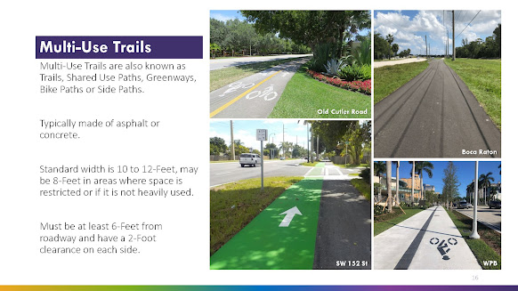
The following is the Marlin Engineering planner's specifications contained in slide 16.

  • The standard width is 10 to 12-Feet, may be 8-Feet in areas where space is restricted or if it is not heavily used.
  • The path must be at least 6-Feet from roadway and have a 2-Foot clearance on each side.

See Page/slide 16 of the Multi-Use Trail & SMART Plan Connectivity Study, Bicycle & Pedestrian Advisory Committee Meeting, November 16, 2021

Why is the above important?

Because here are some photos taken of the SW 136th Street path where you can clearly see significant portions of the path where these important guidelines are not met:


Observable issues (above). The path at these points are neither 6 feet from the roadway nor is there the stated recommended two feet clearance on the other side (backs up to a thick hedge - you can see why that would be a problem when dealing with handlebars, etc.)

Immediately above and below - there is no explaining splitting the path into two separate 4 foot sections. Does it really equal a useable 8 feet? Is the sidewalk traffic really that bad that Palmetto Bay officials feel the need to created a divided pathway to separate oncoming users? There is no 2 foot buffer to the inside portion as well as a lack of 6 feet buffer from the street. The only way to describe this is the useable swale area (water runoff) and resident/guest parking is gone, essentially the entire right of way has been paved over.


Above - twisting and turning with an abrupt reduction from 6-8 feet to a standard 5 foot sidewalk, clearly not within the Marlin Engineering guideline.

Below - where is the safety buffer from traffic? Cars can and will easily pull off the road and onto the pathway, placing users at risk.

CLICK HERE to view prior related posts on shared paths including 136th Street, Red Road and Old Cutler Road, both in Palmetto Bay as well as in Cutler Bay.

*Marlin Engineering is facilitating Palmetto Bay's Multi-Use Trail & SMART Plan Connectivity Study

Sunday, March 13, 2022

True bike mobility - examples of bike mobility options - see for yourself. What is your vision?

The video documents conventional bike lanes, pained bike lanes v protected bike lanes, as well as a shared path (where the roadway remains marked for shared use by bicyclists - identical to the Old Cutler Path).  This information is important as current Palmetto Bay officials are not satisfied with the SW 136th Street project - next up are other streets, including SW 184 as well as Coral Reef Drive - January 28, 2022, Next issue - do we turn Coral Reef Drive into the next SW 136th Street? Time to get involved.

 
Examples of different bike lanes - traditional (conventional) - along SW 62nd Avenue (in front of Miami's Community Newspapers) 0:01:42 Painted, traditional non-separated bike lane. 0:02:17 Sharrow and wide sidewalk 0:02:43 example of a curbed protected bike lane 0:03:38 another example of a curbed protected bike lane 
More to follow on bike lanes.

When you look, please consider what you prefer as a motorist as bike lanes are for drivers as well. How? Because a bike lane places the cyclists in their own lane, rather than taking the lane in front of the motorist. Remember, a shared path is not a dedicated bike lane. See December 17, 2018, Taking a close look - Old Cutler Bike Trail - designed use, rules of the road - Types of bikeways - 2 discussed here: paved path & sharrows. Cyclists may choose to use it, but is not required to do so - and there are many examples I can give as to why 'taking the lane' is preferable, and safer, for a cyclist than riding a shared path.

Also think about what you would prefer as a homeowner living on that street. Look to SW 136th Street to see the loss of swale (drainage, landscaping - green space) and parking. Does the SW 136th Street project get bicyclists off the roadway. In then end, the SW 136th Street is just a disjointed collection off standard size sidewalks in part with wider sidewalk  sections in other sections. Barriers remain in many areas including signage, abrupt curves as well as utility boxes and poles. It is neither well thought out or well designed.  See: October 2, 2021, Special post - Photo(s) of the day. Reader submitted photos of the Palmetto Bay designed shared path. Or is it a car park?

Another issue with projected bike lanes - what happens at time of deliveries - or garbage / recycling pick up? How are vehicles going to move down streets during these events? Delivery vehicles will remain in the street as they cannot pull off the road due to the barriers created for the protected bike lanes.  But at least no one will be parking on in the protected bike lanes (as they do on the shared paths) - the curbing or barriers prevent any such intrusion. 

We are seeing the impact of share paths in Palmetto Bay - far too many examples of vehicles parking on them as the right of way (swales) have been lost, so now where do guests or large families park? I have documented many such violations throughout this blog. So we need more?

This post is another in my series of relating to local issues, local places. This is part of a developing "taking a close look at" or "Fact Checking" series on issues and places in and around Palmetto Bay and our south Miami-Dade Communities.

Wednesday, February 2, 2022

Update on the Multi-Use Trail & SMART Plan Connectivity Study

The Multi-trails study is not listed on the agenda for the February Regular Council meeting.

I was advised that there has been an extension provided in order to finalize the draft report and conceptual plan sheets due to the latest COVID wave of Dec/Jan. Additionally, it is believed that there will be updated drafts that will be submitted to the Village, TPO and County in the next week or so. I will try to obtain and provide these documents in advance.

Perhaps this matter will go before the Village Council sometime in March. 

I am hopeful to receive a date, which I will pass on upon receipt.

CLICK HERE to view prior posts related to the Multi-Use Trail & SMART Plan Connectivity Study.


Monday, January 31, 2022

How and where will it all fit? Design definition of a multi-use trail – as defined by the Palmetto Bay study. Issues and concerns that should be addressed before any alternatives are greenlighted.

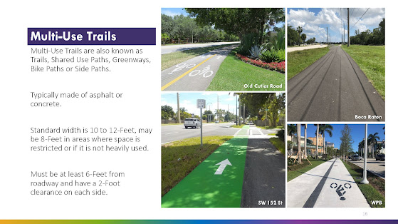
I have been asked to provide more information regarding the proposed multi-use trail, a possibility for Coral Reef Drive (and SW 184).  I have posted page 16 of the draft study below. Note this is limited to the multi-use trail, not the alternative plan if protected bike lanes were installed. The protected bike lane alternative will be the subject of a future post if there is interest from readers.

As indicated on page 16, for purposes of this study, Marlin Engineering lists the design (and impact) of a multi-use trail as follows:

·       Standard width is 10 to 12-Feet, may be 8-Feet in areas where space is restricted or if it is not heavily used.
·      
Must be at least 6-Feet from roadway and have a 2-Foot clearance on each side. 
(See below)


SPACE REQUIREMENT: That means total space dedicated to the Multi-Use Trail would be 16 to 20 feet from the edge of the roadway [minimum 6 feet from road, plus minimum 8 feet (where restricted) plus an additional 2 feet of clearance from the edge of the path furthest from the street].

IMPORTANT ISSUES: The logical question here is whether there is sufficient open right of way along Coral Reef Drive? I have previously identified the numerous mature shade canopy trees as well as a historic coral rock wall in many areas.

My issue is what trees will be destroyed for a project that may not fit within the design parameters set by Marlin Engineering? Or would the Coral Reef Multi-Path be forced to take the same type of modifications used on SW 136 Street such as severe reductions or splitting the path in two to allover for trees in a center median?

The discussion above leads to many fair questions to be discussed when and if these proposals come before the mayor and village council. That is, unless any changes would be handled administratively as attempted (and, thankfully, denied) for the Palmetto Bay Village Center.

Applying the Marlin Engineering Design recommendations to the actual 136 Street buildout:

Obviously the SW 136 Street Multi-Path was not designed by Marlin Engineering as that path does not conform to the design criteria.  There are many areas where the 136 Street path is significantly less than 8 feet, some areas only as wide as the standard sidewalk they sought to upgrade from. There are many areas where the SW 136 Street path is significantly closer to the roadway than the 6 feet Marlin Engineering’s design recommends. That same 136 Street path also suffers many areas where the path has a hard end to obstructions including fences, walls and hedges – meaning there is no 2 foot buffer for the non-street side of the path – any bicyclist attempting to use the path would need to stay to center in order to avoid conflicts with these obstructions, thus severely reducing the effective width of that area of the path.

Background - prior related post - see: January 28, 2022, Next issue - do we turn Coral Reef Drive into the next SW 136th Street? Time to get involved.

TO BE CONTINUED ... stay tuned and check back for updates

Thursday, December 2, 2021

Construction of the 87th Avenue Bridge - coming to Palmetto Bay in Fall, 2022, at least per this County Fact Sheet

The information provided in this fact sheet do not appear to be consistent with the actions planned by the current members of the Palmetto Bay council. This project is moving forward, at least according to this update:

Fall 2022 - we are in the last month of 2021.

How to register and participate: Virtual Public Meeting Regarding the SW 87th Avenue Bridge Project, Wed., 12-15-2021, 6:30 to 8:00 PM

Updated information / link to register for the meeting.

The Miami-Dade County Department of Transportation and Public Works has scheduled a VIRTUAL public meeting to discuss the SW 87th Avenue Bridge over the C-100 Canal project.

Miami-Dade County has scheduled the meeting Palmetto Bay officials have declined to have –a detailed public meeting on the 87 Avenue bridge. The advertisement was posted in the Miami Herald on Page 12A, Wednesday, December 1, 2021.

As stated in the meeting notice, "the project consists of the Design and Construction of a new bridge that will provide vehicle travel lanes, dedicated bike lanes with physical raised separation from vehicle traffic, curb & gutter and sidewalk in both directions, northbound and southbound. The project scope includes a new roadway, storm water drainage system, signing and pavement markings, bridge lighting, fencing and landscaping along the project."

Furthermore, the meeting notice states that, "The objective of the project is to provide connectivity for motorists, cyclists, and pedestrians along SW 87th Avenue and to improve traffic network along the SW 87th Avenue corridor within the Village of Palmetto Bay. funding for his project will be provided from the Road Impact Fees of District 5, pursuant to Section 33E of the Code of Miami-Dade County."

Please use the links below for additional information and to register for the Zoom meeting. For additional information from Miami-Dade County concerning the project, please email DTPWOutreach@miamidade.gov


Note - photo above is not the actual rendering for the bridge currently in design. 


SPECIAL NOTE: Thank you Miami-Dade officials for scheduling a meaningful public meeting. See my prior post of October 4, 2021, OPINION: It is time for this mayor and council to come clean and hold a proper town hall update. Residents' voices should matter. Come out of the shadows on the bridge. - Residents' voices should matter, but is has become a mere a catch phrase here in Palmetto Bay since December 2018.. 

Wednesday, December 1, 2021

Miami-Dade County DTPW sets a critical Virtual Public Meeting regarding the 87th Avenue bridge - set for December 15, 2021, from 6:30 p.m. to 8:00 p.m.

Miami-Dade County has scheduled the meeting Palmetto Bay officials have declined to have –a detailed public meeting on the 87 Avenue bridge. The advertisement is posted below. Miami Herald subscribers can view this Miami-Dade County advertisement on Page 12A, Miami Herald, Wednesday, December 1, 2021.

This meeting didn’t just pop up overnight. I am not sure why it was not discussed by the current mayor and council members at the Palmetto Bay Special Council meetings held Monday, November 29. Perhaps they were caught by surprise at the public notice in the Wednesday paper (although advertisement deadlines required that this advertisement be submitted days prior to the Monday meetings). Unfortunately, the current Palmetto Bay administration appears to prefer to restrict information rather than promote robust public discussions.

Regardless – who should attend? (I bet you, the reader, meets at list one of those listed below):

·       Those concerned (for and/or against) the bridge. 
· Cyclists who want input as to the planned dedicated bike lanes (including, not just for the bridge, but for all of 87 avenue). 
·       Those interested in connectivity for golf carts.
·       Pedestrians (who plan on walking this section – to see what protective walking areas the County has planned as they are not included in ‘dedicated’ bike lanes).
·       Those interested in ensuring that drought resistant native plants will be used for landscaping.
·       Those interested in this project adding value to the area (more than ‘just a bridge’ – the additional amenities).

Note the project will include lighting, fencing and landscaping - all of which will impact the immediate area.

Also note: This is a Miami-Dade County planned project, so we want to watch this project to ensure that it does not become another 136th Street MEGA sidewalk fiasco as planned by Palmetto Bay officials.

Also note - the planned amenities are those planned by Miami-Dade County and were never mentioned or sought by Palmetto Bay Officials during the many months of negotiations were held on the proposed Interlocal A

More information (for those who truly want to be ‘in the loop’ on this matter: email: DTPWOutreach@miamidade.gov


Tuesday, September 21, 2021

Important Palmetto Bay meeting for both motorists and cyclists - Wednesday, 9/22 - bike lanes or two more 8-10 foot mega paths?

Developing path on
SW 136 Street
Who here is thrilled with the  SW 136th Street project? What was once a complete street design with bicycle lanes morphed to what is frequently referred to as the MEGA Sidewalk that varies from 10 to 8 feet, even back to a mere standard sidewalk size in part. In fact, this 136 Street multipath places cyclists and other users on the same sidewalk in front of Howard Drive Elementary, which many view as a poor choice of mixed uses during the hours of school drop off and dismissal.

Original plan rendering

The fact is that the bike lanes were taken out of the 136 Street plans. So cyclists will still be required to “take the lane” only now the lanes involved on SW 136 Street will be reduced to 11 feet, thus making it a tighter fit and increasing driver angst toward cyclists. 


Here is your opportunity to get involved. Marlin Engineering shall host a virtual second Public Workshop, Wednesday, September 22, 2021, at 6:00 PM. During the virtual Public Workshop, Christina Fermin, Project Manager for Marlin Engineering shall make a presentation of Palmetto Bay’s Multi-Use Trail Feasibility Study and there will be time for questions and comments.

The Palmetto Bay Multi-Use Trail & SMART Plan Connectivity Feasibility Study will identify and assess existing conditions for bicycle and pedestrian connectivity along SW 144 Street, SW 152 Street, SW 168 Street and SW 184 Street, between the South Dade Transitway and Old Cutler Road. The study will consider multi-use pathways, sidewalks and/or protected or buffered bicycle lanes.

The study will evaluate up to two alternatives for two of the above-mentioned roadways. The final plan will include 15% design plans for up to two corridors connecting Old Cutler Trail and the South Dade Trail. This study is anticipated to be completed by November 2021. The workshop will be conducted using a teleconferencing platform and broadcast live. CLICK HERE for details on how to participate.

Wednesday, September 8, 2021

Let’s get back to thinking green! We have a 2-year limited window for Palmetto Bay's $12,282,434 American Rescue Plan Act (ARPA) funding. One very positive idea - let's put that ARPA money to work to save our local environment; assist those without the financial resources to hook up. It benefits all of us – and Biscayne Bay.

History: May 20, 2013, Mayor Stanczyk and the 2013 Village Council petitioned the Miami-Dade County Commission for an administrative waiver - a 10 year extension before requiring the homes located within the Franjo Triangle to hook up to the water and sewer service (section 24-43.1 of the Miami-Dade County Code). View: Palmetto Bay Resolution 2013-47.

So what has happened in that time? How many have hooked up to sewer? Worse yet, are we sure that the aged septic systems are not failing?

Now we have an opportunity, Palmetto Bay's $12,282.434 American Rescue Plan Act (ARPA) funding. Palmetto Bay officials need to get this right the first time or future expenses will lead to even more tax increases.  This money can properly provide relief for those most in need in our community. Let's use the funding correctly and not on items that may not pass auditing in future by the Federal government, by providing funding sewer hookup fees for those in District 3 that face a huge layout of funding in 18 months

Sewer hook ups may not be sexy, but saving our environment is. My proposal makes better use of Palmetto Bay's limited funding under the American Rescue Plan Act. It gets these homes off septic and onto the sewer system extension that both Commissioners Moss and Sorenson worked with us (Palmetto Bay) to make happen. Save Biscayne Bay. 

This money needs to be invested wisely, not squandered.  So, let’s get people off aged septic systems and hooked up to sewer. Let’s get Palmetto Bay back to thinking green! Let’s actually ‘build back better’! Hook ups are actually a requirement by 2023 and Miami Dade water and Sewer will begin placing liens on these housing units if we don’t help them.

The sewer over septic priority cannot be overstated. Palmetto Bay has another ticking time bomb on its hands. The Miami Herald reported that Sea rise makes septic tanks ‘ticking bombs.’ Why does Miami-Dade still allow them? by Alex Harris, January 15, 2021. For those without a Miami Herald subscription, the Miami Herald reported that:

Miami-Dade’s 120,000-plus septic tanks — an aging, leaky system for disposing of human waste that experts have pointed to as a public health and environmental hazard for bay waters since the 1950s. Yet, despite periodic calls as early as the 1960s for ambitious sewage system upgrades, the Herald found that the county has put only a small dent in the septic mess over the decades — and actually continues to issue permits for new ones.

Money, as usual, is the big stumbling block for a clearly defined problem with straightforward solutions.

Homeowners don’t like paying for it, and neither does the county. The most recent estimate for Miami-Dade was $3.3 billion to get rid of most of them, and the cost per house can balloon far past the average $10,000 price tag. That’s why residents have been granted reprieves from orders to hook into nearby sewage lines for decades.

My proposed solution: Use a substantial portion to go green and complete the sewer system. Homes need hook ups. Here is a one-time gift of money (our Federal tax dollars at work) that may never be repeated.

Photo Credit: Official Pinecrest, published in the Community Newspapers.
It can be done. Pinecrest has been forward thinking: using this money for big ticket items that they have been advocating for. So should Palmetto Bay. Pinecrest was notified that it would receive approximately $8 million of Federal funds that could only be used for very specific matters including water projects. The Village Council and staff worked quickly to take the necessary steps to use most of those dollars to finally resolve the water issue in Pinecrest. See: Community News, Pinecrest Breaks Ground on Water Project, August 22, 2021.

Another positive point - this is a one-time capital expense. Many of the slated uses set by Palmetto Bay officials are just a 2 year bridge, after which the taxpayers will have to pick up the continuing expenses of the employees slated to be hired. Will this lead to even more tax increases in the future?

Let's really build back better! – and smarter. This ARPA money is truly a one-time opportunity.

BACKGROUND - PRIOR RELATED POST: See September 3, 2021, Budget review - my first statement of concern and it is a big one: how the Village plans on spending $12.3 million.

Thursday, August 12, 2021

Update on the SW 136 Street project. Village renderings as well as private photos and video are provided.

EDITOR'S NOTE:  Who doesn’t love Sesame Street? "One of These Things" was a song regularly used on the show where the children would be shown a group of four items, one of which was different from the other three. Viewers would learn to identify the item which didn't belong. Not everything is equal. This game provides a lesson in learning to look to find the detail and discern subtle differences.  Some differences are not subtle. 
It’s a good game for children, but it is not a game that local governments should be inflicting on residents. This is especially true when the actual differences impacts their homes, which for most, is the largest investment we make in our lifetime. It is not a game.

So with that lead in, Palmetto Bay residents once again are called upon to play the game of "some of these sections are not like the others". People are starting to compare - sections of the so-called shared path.  And affected residents are starting to notice that not all sections are created equal. Why do some residents have the full 10 feet imposed while others suffer less, 8 feet or worse, at least one section where the sidewalk is the standard 5 feet? That is right! Five (5) feet!

This 5 foot section is located just east of 77th Avenue
Not really much of a so-called bicycle upgrade

It is a fair question to ask who made these decisions that impact their property values and ability to park on the swale? Were there private, unadvertised meetings? 

It is also a fair question to ask whether Pinecrest officials would ever consider inflicting such a project on their residents, on their side of SW 136th Street (or anywhere else in Pinecrest for that matter)? I bet not.

Why are trees being knocked down in some areas while the path was reduced to the standard 5 feet to save the trees. 

Many want to know how residents in that area pulled off 5 feet while they are suffering 8 to 10 feet.  

I am documenting here that 5 feet has been poured in at least one area (photo above), yet village officials continue to advise residents that this project includes an 8 to 10 foot "shared use path" (see rendering immediately below), 

Note: The Village representation as to the 8' to 10' width are identified with red arrows and circles

You can't hide the cement. The 8 to 10 foot width range is far from the truth. The cat is out of the bag as a friend of South Dade Updates (FOSDU) called me out to the scene to witness the in fact all sections are not being treated equal. Please view the videos and photos.


The dirty little secret (until now) is that shared path narrows as the standard 5 foot sidewalk in at least one section (see video above and photo below). Who else will get a special dispensation for a reduced 5 foot wide path? Remember, the project is far from complete.


Saving the trees - a worthy goal: An unnamed source within the project contractor advised that the reduction to 5 feet for the section documented above was done in order to save the trees. Save the trees! There is otherwise sufficient right of way to pour a 20 foot path.  Wow. let's work together to save more trees.

why are changes keep being made for some, but not all. My purpose here is to really keep you in the loop as to this SW 136 Street Project. Perhaps more affected residents need to speak out and make their voices heard before the fate of their property is sealed in concrete.

Path section located west of 77th Avenue. No parking.
Essentially all green space removed.

BACKGROUND:
For background, please see my post of August 2, 2021: How will SW 136th Street look and function when completed? Some fair questions. Remember, this shared path will have all the effectiveness of the Old Cutler Shared Path. It is a shame. I have always keep my constituents, now my readers in the loop.  Please review my concerns expressed about the many questions about the final look and function of SW 136 Street. I have also heard that there have been some changes made based upon special input. The path with has shrunk in some areas. It may zig where it was programed to zag or go straight. We will all just have to wait and see as no one is keeping us all in the same loop as to those pesky details. It is strange (and sad) that some people have been provided significant input while others have been kept in the dark or told simply that this is 'a county project'. That is not true, this is a JPA and Palmetto Bay has designed it.

Monday, August 2, 2021

How will SW 136th Street look and function when completed? Some fair questions. Remember, this shared path will have all the effectiveness of the Old Cutler Shared Path. Photos and links provided.

There are many questions about the final look and function of SW 136 Street. I have also heard that there have been some changes made based upon special input. The path with has shrunk in some areas. It may zig where it was programed to zag or go straight. We will all just have to wait and see as no one is keeping us all in the same loop as to those pesky details. It is strange (and sad) that some people have been provided significant input while others have been kept in the dark or told simply that this is 'a county project'. That is not true, this is a JPA and Palmetto Bay has designed it.

One thing is important: safety. The Old Cutler Path was built in different times and has not been updated in years by Miami-Dade County other than striping and other markings on the path. Shared paths are far from immune to car versus cyclists or pedestrian accidents. See a prior related post of June 24, 2020, Yet another car v bike conflict along the Old Cutler Trail – a multi-use path, not a dedicated bike lane. I have posted other significant past posts that will provide information as to sharrows and shared paths in general, other posts provide information and opinion as to Old Cutler Road and the Old Cutler Trail specifically.

New construction should be built to take advantage of the latest safety updates.  I post here some photos taken at another Miami-Dade County shared path/trail.  Please view the safety equipment.  Simple, but include lighted crossing fixtures and painted crosswalks. Most importantly, there are bollards installed to prevent motorized vehicles from using the trail path. 


And think again if you don’t think there is a risk of cars will be using the 136 Street shared path.  Take a look at this video documenting a frustrated driver taking to the Old Cutler Shared path on February 19, 2021. You can see the foreshadowing of intent from the very beginning of the video. The driver finally reached the breaking point 50 seconds in the video and begins the long drive down the shared path all the way down or at least much closer to the intersection at Coral Reef Drive. Wow a private lane!  


Outta the way walkers, joggers and cyclists!

What we know. 

  • We know about the significant loss of trees along SW 136 Street (with some 40 year trees being replaced with some new much smaller plantings). 
  • We know there will be no bike lines, so cyclists will still be legally permitted to use the street (so no gain for the motorists), but again, what about the safety enhancements for the shared path. 
  • Will there be anything better than a curb?
  • We know that some get modifications while others are definitely not being kept in the loop.
  • Most of us will have to wait for the project to take shape to be able to envision what the final project will look like,

Monday, July 26, 2021

What a difference a change in administration makes - Palmetto Bay update. Why make it a park when it serves well as a debris dumping ground?

Here is an update on the FPL easement property (under the powerlines that run between SW 140th and 141st Streets East of SW 77th Avenue). Is it passive park? No, it appears to be serving as a debris staging site. My initial thought is whether Village officials are looking the other way while residents suffer a violation of their rights guaranteed under the Palmetto Bay Neighborhood Protection Charter section. I discuss this at the bottom of this post.
But first, please tell me that this is not the best use for this property as envisioned by the current mayor and village council. 

There were much better ideas.  Here is the vision that Palmetto Bay and residents participating in the Palmetto Bay Parks Master Plan process had for this property while I was mayor:
Please be mindful that the above was a concept, far from a done deal, as we want to involve the neighbors in the process. 

But seriously, which use do you prefer? And, BTW, fair questions: Should this debris be secured with a environmental barrier as well as a safety fence? Prior administration thought this land better suited for a park. Do you want to see kids playing on this debris pile?

A Parks Master Plan process was being held in 2018. While serving as your mayor, my vision for this property was a passive park.  See a PRIOR RELATED POST of May 23, 2018, Update on the Parks Master Plan process. Next visioning session is set for Sat. June 2, at 9:00 AM at OCPC. This prior post should serve to document the past process, past plans, as well as what a difference a new administration makes. 

WHERE DOES THIS DEBRIS ORIGINATE? - neighbors that I have communicated with believe that this debris comes from the SW 136th Street MEGA sidewalk project. No one really knows as no one from the Village provided advance notice of the coming debris dump to the residents of the residents of SW 140th Street

This project was designed by Palmetto Bay, but is also a joint project involving Miami-Dade County and Pinecrest. Palmetto Bay allowed the bike lanes to be removed, but agreed to create an 8 to 10 foot shared use path solely on the Palmetto Bay side. So not only does Pinecrest save more trees, not only does Pinecrest not have to shoulder the burden of a loss of right of way, but Palmetto Bay residents appear to be left holding the bag for debris staging.

Debris field or a passive park? You decide how this new direction is going for Palmetto Bay.

My recommendations - Clean it up. Take the SW 136 debris immediately to its final location. Don't burden the residents of SW 140th Street with such unsightly and potentially harmful debris. 

What happened to the protection of Palmetto Bay residents voted un under the Neighborhood Protection Amendment to the Village Charter?

All Single-family residential properties shall be protected from the negative impacts of adjacent or nearby non-single-family-residential uses.

10.2.1 All non-single-family-residential developments, structures, or use (that is/are a direct or indirect result of that development, structure, or use) in, adjacent to, or nearby any single-family zoned properties shall not disrupt or degrade the health, safety, tranquility, character, and overall welfare of the adjacent or nearby single-family residential properties by creating negative impacts on those properties such as density, intensity, noise, light, glare, dust, odor, vibration, traffic or run off that exceeds that of adjacent single-family properties. Nothing herein should be construed or applied to abrogate the vested rights of a property owner. 

Tuesday, July 20, 2021

Palmetto Bay Bridge - the definitive statement from the Village Attorney - more post mortem - photos, video and links provided.

The bridge “fight” is over. The video clip embedded below speaks volumes and has led me to examine as to where we are as well as why we are in this situation. This fight ended quicker than a Mike Tyson fight. 

In review, my first thought is so much for the "fight" against the bridge.  Secondly, all we seem to have to show for this “fight” are two completing camps on this divisive issue. 

It is becoming obvious that there is no fight, or at least much of a fight. The honest voice from the council dais is saying that this is done; let's move on to other pressing business while the elected officials appear to want to pretend they are actually doing something. They aren’t other than to perpetuate a false drama.

This council knew it was going to be a major issue. It certainly was an issue during the campaigns. I guess too many officials never move out of campaign mode into getting it done mode. Palmetto Bay was run off the road on this issue. It wasn't pretty, regardless of which side you were on (I have always opposed bridging and lead the successful fight against in during much of my time in office). I warned the current mayor and the 2019 village council (pre-2020 elections) that this issue was coming. Yet it seems that 4 out of 5 of that group claimed surprise. See a prior post of December 15, 2020, 2021's first test - the bridge is back. Will it unite or divide Palmetto Bay? Will it happen without input from Palmetto Bay's so-called leaders? There was no preparation to meet this challenge. 

I asked the question "What did they know and when did they know it?" (our current elected officials). February 2021 came and went without any elected officials keeping residents in the loop, updating them on preparations for combating the bridge. Why, obviously because there was no preparation, plan or vision. See another prior related post, this one posted February 2, 2021, Bridging Palmetto Bay - the plan is back and apparently this has been put together without any opposition or input from current Palmetto Bay officials. It is incredulous to think that our elected officials met with our County officials, with a new County Commissioner, without asking proper questions or being offered the updates on the plans for the bridge. 

So why is money begin spent for the Social Media specialists as well as attorneys to attend these "mediations"? What are the deliverables for the tax dollars being spent?
  • You want "no right turn signs"? The County has always been reasonable. What has been unreasonable has been the cost of enforcement. When does Palmetto Bay reach the number of 'no turn' signs where they lose their effectiveness?
  • You want "traffic tables"? We have secured these anytime we have asked (at least while I was in office). And I think we have reached the point of diminishing returns on them at this point.
  • Landscaped chicanes? We have been allowed to install those as well (I actually prefer them).  Approved for use and installed in 2008.
  • Roundabouts? They work. I even got the County to pay for them. Not everyone likes them, but traffic lights are so awkward. Holding drivers up when there is no traffic and tend to go out in bad weather. Current Palmetto Bay leaders have a lawsuit pending to avoid the County's offer to fund and build a roundabout at SW 87th and 174.
  • Traffic diversion, turning some streets one way? All could be done, at least at one time.
  • We did get the County to put in at least one traffic signal that I can recall - 87th avenue and Coral Reef Drive - through negotiation and in collaboration with our commissioner Katy Sorenson - once again, we thank you Katy! 
  • Also lighted crosswalks - Old Cutler Road/174, numerous spots on 82nd Avenue and on 168th street.
More examples of concessions from Miami-Dade County waiting to be enacted? See July 21, 2017: Next Palmetto Bay debate: should we reduce speed limit on village managed roads to 25 MPH? Your voice matters - BREAKING NEWS- Friday, July 21,2017: Miami-Dade County has authorized the Village of Palmetto Bay to reduce the village speed limit  (on Village jurisdiction Roads) to 25 mph. Again, what are your thoughts? I started the discussion back in 2017. This is a debate that needs to occur within Palmetto Bay, amongst our residents. The County is good to go (or at least was good at one time).

But all this was through a well-developed quality working relationship built while I was in office between Palmetto Bay and the County.
  • In fact, the County has even looked away when Palmetto Bay has conveniently failed to comply with the requirements that the 'temporary traffic tables' (informally identified as the black rubber mats) be removed after 90 days.
The current Palmetto Bay Mayor and some council members appear to want to fight rather than work with Miami-Dade County. Contrast pre-2019 when the County would assist in design and payment for traffic roundabouts while I was mayor with the actual lawsuits filed and maintained to fight the traffic circle proposed for 87th and 174. This is after some (I wont name her here) took credit for obtaining the traffic circle, yet flip flopped and fought it when some residents objected at a meeting. Facts are facts and here is another good background post of February 11, 2020, Lawsuit? What lawsuit? Palmetto Bay is now a bit player in future decisions to be made regarding traffic solutions along SW 87th Avenue and surrounding areas.

The video embedded below is an excerpt from the Palmetto Bay Regular Council Meeting, July, 2021: Village attorney response to query from Council Member Marsha Matson. It is fact based and appears to me to be a professional and proper way of setting expectations.

His statement: "The County is going to build that bridge and they've made that very clear; that nothing is going to stop that construction."


NOTE: This video was taken from another site. I did not prepare or had any input on the preparation or posting of the video from this YouTube site, but it does present important information. Anyone interested should watch the full video of the entire meeting - don't wait for the minutes to be posted as this current mayor has seen fit to post a very limited number of meeting minutes - I believe only 4 meetings held since January 2019 have minutes posted out of approximately 132 meetings held to date.

CLICK HERE to view some prior related posts relating to the 87th avenue bridge.

What do I think went wrong? Agreements have not been kept by Palmetto Bay - causing a crisis of credibility and leading Miami-Dade County to move on without Palmetto Bay's input.

Included, but important to set out here is a prior related post of January 8, 2018, entitled: "Commissioner Cava issues her decision. She is NOT supportive of the 87th Avenue bridge. She will continue to work to find solutions for all." These were the days of collaboration and inter-governmental inclusion / partnership. Look at the list of past projects that were worked out through collaboration with the prior administration of Palmetto Bay. 


Ask yourself what happened to the partnership once the new (current) administration took over on December 5, 2018. Projects have been pushed back, cancelled, modified, basically, it is my observation that the commitments were not kept by Palmetto Bay, thereby forcing the County's hand to move forward on the 87th avenue bridge. Ask yourself, can the bridges for 77th Avenue be too far in our future?

You want more examples? There are many that can be listed and I want to keep this post relatively short, but here is just one:


This council needs to spend more time on the issues and less time on distractions, spin and photo ops.