Showing posts with label Marlin Engineering. Show all posts

Saturday, March 19, 2022

Marlin Engineering provides guidance on a proper shared path. This is important for Coral Reef Drive & 184 – and the specifications demonstrate that the 136th Shared Path is more a mess than a safe path – important details.

Do it right, or don't do it at all. The current mayor and this council should not repeat the mistakes made in redesigning the SW 136th Street project. The photos at the bottom serve to shine light on poor planning and defines the term forcing a square peg in a round hole - who is really happy with SW 136th Street? The results really do not fit in this particular place or situation. 

Important point: There is no legal requirement to make profound changes to either SW 184 or Coral Reef Drive - so the Palmetto Bay mayor and council should resist temptation to spend the tax dollars, unless the project brings quality improvements to those streets. Don't sacrifice historic coral rock walls and magnificent shade and clean air producing canopy trees to a vanity project.

The first question is whether a shared path properly fit in the existing street right of way.  This Coral Reef / 184 project is not one of a pre-planned area. These areas will require significant work arounds due to many existing obstacles such as power poles, coral rock walls and many, many historic trees. Marlin Engineering* has provided recommended specifications regarding a proper shared path (see figure and description posted below). This is important for Coral Reef Drive & 184 – and the specifications demonstrate that the 136th Shared Path is more a mess than a safe path – important details.

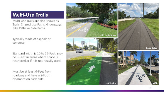
The following is the Marlin Engineering planner's specifications contained in slide 16.

  • The standard width is 10 to 12-Feet, may be 8-Feet in areas where space is restricted or if it is not heavily used.
  • The path must be at least 6-Feet from roadway and have a 2-Foot clearance on each side.
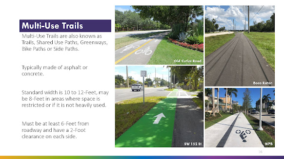
See Page/slide 16 of the Multi-Use Trail & SMART Plan Connectivity Study, Bicycle & Pedestrian Advisory Committee Meeting, November 16, 2021

Why is the above important?

Because here are some photos taken of the SW 136th Street path where you can clearly see significant portions of the path where these important guidelines are not met:


Observable issues (above). The path at these points are neither 6 feet from the roadway nor is there the stated recommended two feet clearance on the other side (backs up to a thick hedge - you can see why that would be a problem when dealing with handlebars, etc.)

Immediately above and below - there is no explaining splitting the path into two separate 4 foot sections. Does it really equal a useable 8 feet? Is the sidewalk traffic really that bad that Palmetto Bay officials feel the need to created a divided pathway to separate oncoming users? There is no 2 foot buffer to the inside portion as well as a lack of 6 feet buffer from the street. The only way to describe this is the useable swale area (water runoff) and resident/guest parking is gone, essentially the entire right of way has been paved over.


Above - twisting and turning with an abrupt reduction from 6-8 feet to a standard 5 foot sidewalk, clearly not within the Marlin Engineering guideline.

Below - where is the safety buffer from traffic? Cars can and will easily pull off the road and onto the pathway, placing users at risk.

CLICK HERE to view prior related posts on shared paths including 136th Street, Red Road and Old Cutler Road, both in Palmetto Bay as well as in Cutler Bay.

*Marlin Engineering is facilitating Palmetto Bay's Multi-Use Trail & SMART Plan Connectivity Study

Wednesday, February 2, 2022

Update on the Multi-Use Trail & SMART Plan Connectivity Study

The Multi-trails study is not listed on the agenda for the February Regular Council meeting.

I was advised that there has been an extension provided in order to finalize the draft report and conceptual plan sheets due to the latest COVID wave of Dec/Jan. Additionally, it is believed that there will be updated drafts that will be submitted to the Village, TPO and County in the next week or so. I will try to obtain and provide these documents in advance.

Perhaps this matter will go before the Village Council sometime in March. 

I am hopeful to receive a date, which I will pass on upon receipt.

CLICK HERE to view prior posts related to the Multi-Use Trail & SMART Plan Connectivity Study.


Monday, January 31, 2022

How and where will it all fit? Design definition of a multi-use trail – as defined by the Palmetto Bay study. Issues and concerns that should be addressed before any alternatives are greenlighted.

I have been asked to provide more information regarding the proposed multi-use trail, a possibility for Coral Reef Drive (and SW 184).  I have posted page 16 of the draft study below. Note this is limited to the multi-use trail, not the alternative plan if protected bike lanes were installed. The protected bike lane alternative will be the subject of a future post if there is interest from readers.

As indicated on page 16, for purposes of this study, Marlin Engineering lists the design (and impact) of a multi-use trail as follows:

·       Standard width is 10 to 12-Feet, may be 8-Feet in areas where space is restricted or if it is not heavily used.
·      
Must be at least 6-Feet from roadway and have a 2-Foot clearance on each side. 
(See below)


SPACE REQUIREMENT: That means total space dedicated to the Multi-Use Trail would be 16 to 20 feet from the edge of the roadway [minimum 6 feet from road, plus minimum 8 feet (where restricted) plus an additional 2 feet of clearance from the edge of the path furthest from the street].

IMPORTANT ISSUES: The logical question here is whether there is sufficient open right of way along Coral Reef Drive? I have previously identified the numerous mature shade canopy trees as well as a historic coral rock wall in many areas.

My issue is what trees will be destroyed for a project that may not fit within the design parameters set by Marlin Engineering? Or would the Coral Reef Multi-Path be forced to take the same type of modifications used on SW 136 Street such as severe reductions or splitting the path in two to allover for trees in a center median?

The discussion above leads to many fair questions to be discussed when and if these proposals come before the mayor and village council. That is, unless any changes would be handled administratively as attempted (and, thankfully, denied) for the Palmetto Bay Village Center.

Applying the Marlin Engineering Design recommendations to the actual 136 Street buildout:

Obviously the SW 136 Street Multi-Path was not designed by Marlin Engineering as that path does not conform to the design criteria.  There are many areas where the 136 Street path is significantly less than 8 feet, some areas only as wide as the standard sidewalk they sought to upgrade from. There are many areas where the SW 136 Street path is significantly closer to the roadway than the 6 feet Marlin Engineering’s design recommends. That same 136 Street path also suffers many areas where the path has a hard end to obstructions including fences, walls and hedges – meaning there is no 2 foot buffer for the non-street side of the path – any bicyclist attempting to use the path would need to stay to center in order to avoid conflicts with these obstructions, thus severely reducing the effective width of that area of the path.

Background - prior related post - see: January 28, 2022, Next issue - do we turn Coral Reef Drive into the next SW 136th Street? Time to get involved.

TO BE CONTINUED ... stay tuned and check back for updates

Tuesday, December 4, 2018

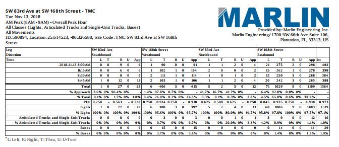
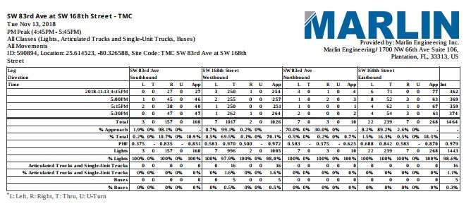
Examples of neighborhood traffic studies - ongoing and recently compiled. Marlin Engineering Traffic & Speed Counts for the neighborhood of SW 83rd Ave between SW 168th Street and SW 165th.

How does your neighborhood compare?

I have posted the Marlin Engineering Speed and Traffic Counts for the neighborhood of SW 83rd Ave between SW 168th Street and SW 165th. The analysis was recently completed and data collected is indicated for November 13 – 16, 2018.

CLICK HERE to download and view the Marin Engineering traffic count, with graphs, note this document is six (6) pages.

CLICK HERE to download and view the Marin Engineering speed count, note the document is eighteen (18) pages.

This posting should be considered an update to prior blog posts including October 17, 2018, Update on Palmetto Bay Traffic Projects - and further updates will be posted as available. This post involved notification through my posting of a photo and information relating to the (then) Current Traffic Studies prepared by Marlin Engineering for the listed areas.

Again, I am posting the same disclaimer as work has always been going on throughout the Village:

DISCLAIMER AS TO OTHER VILLAGE AREAS: There other areas in study, but simply not ready for rollout at this time.  The listed projects have no impact on single neighborhood/street traffic calming such as Traffic Tables and / or traffic enforcement (including CITE program).


Monday, January 9, 2017

Traffic Calming update - Link to Marlin Engineering presentation

Interested in the progress of the Palmetto Bay traffic calming program?  CLICK HERE to view the 24 page/slide Marlin Engineering presentation (power point .PDF - 2.95 MB).  This remains a work in progress. Your observations and concerns - your voice matters.  Please continue to keep me up to date on your questions and concerns - call me at (305) 302-3713 or e-mail at eflinn@palmettobay-fl.gov