Showing posts with label Multi-Use Connectivity Study. Show all posts

Friday, March 25, 2022

Important documents - FINAL REPORT - Village of Palmetto Bay Multi-Use Trail & SMART Plan Connectivity Study

The Multi-Use Trail & SMART Plan Connectivity Study documents are in and I am making them available to you. I was advised that the consultants will make their presentation to the Village Council at the April 4, 2022, regular council meeting. Of course, everything is always subject to change.

Regardless here are the documents for the Village of Palmetto Bay Multi-Use Trail & SMART Plan Connectivity Study – 

Feasibility Study –
Complete  Report -  392 Pages – 132.4 MB
Report Only     -    69 Pages –   15.9 MB
Appendix Only      -  323 Pages – 117.6 MB

The documents are large downloads, so be patient.

The Palmetto Bay Multi-Use Trail & SMART Plan Connectivity Study was prepared by MARLIN Engineering, Inc, one of Palmetto Bay’s traffic and engineering service consultants. 

This was a $100,000.00 Study approved by the Village Council on September 14, 2020: Palmetto Bay Resolution 2020-84

As always, please contact me to discuss any questions or concerns.

Wednesday, March 23, 2022

Protected bike lanes – the recommendation of the Miami-Dade Bicycle Pedestrian Advisory Committee (BPAC) BPAC Reso #5-2021 for SW 152nd & SW 184th Streets

The Miami-Dade Bicycle Pedestrian Advisory Committee (BPAC) reviewed the presentation of Marlin Engineering. After hearing the presentation and reviewing the various factors, the members present of the BPAC voted unanimously in favor for Protected Bike Lanes for SW 152nd Street & SW 184th Street. 

CLCK HERE to read the entire resolution of the Miami-Dade Bicycle Pedestrian Advisory Committee (BPAC) (BPAC Reso #5-2021).

The recommendation of the BPAC is consistent with the survey taken by Marlin Engineering - the survey results also indicating a preference for Protected Bike Lanes for SW 152nd Street & SW 184th Street. 

Marlin Engineering will present the final Village of Palmetto Bay Multi-Use Trail & SMART plan Connectivity Report Study at the April 4, Village Council Meeting.

IMPORTANT NOTE: 
There is no requirement for the mayor and council to make any changes to either Coral Reef Drive or SW 184th. This is all discretionary. "Keep as is" is an option. There is no compelling need to make changes to either road.

Either way, moving forward on both SW 152nd Street & SW 184th Street, will bring profound irreversible changes to those streets, both in function and aesthetics, so it is important to do it right, if it is to be done at all.  

Wednesday, February 2, 2022

Update on the Multi-Use Trail & SMART Plan Connectivity Study

The Multi-trails study is not listed on the agenda for the February Regular Council meeting.

I was advised that there has been an extension provided in order to finalize the draft report and conceptual plan sheets due to the latest COVID wave of Dec/Jan. Additionally, it is believed that there will be updated drafts that will be submitted to the Village, TPO and County in the next week or so. I will try to obtain and provide these documents in advance.

Perhaps this matter will go before the Village Council sometime in March. 

I am hopeful to receive a date, which I will pass on upon receipt.

CLICK HERE to view prior posts related to the Multi-Use Trail & SMART Plan Connectivity Study.


Monday, January 31, 2022

How and where will it all fit? Design definition of a multi-use trail – as defined by the Palmetto Bay study. Issues and concerns that should be addressed before any alternatives are greenlighted.

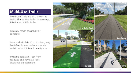
I have been asked to provide more information regarding the proposed multi-use trail, a possibility for Coral Reef Drive (and SW 184).  I have posted page 16 of the draft study below. Note this is limited to the multi-use trail, not the alternative plan if protected bike lanes were installed. The protected bike lane alternative will be the subject of a future post if there is interest from readers.

As indicated on page 16, for purposes of this study, Marlin Engineering lists the design (and impact) of a multi-use trail as follows:

·       Standard width is 10 to 12-Feet, may be 8-Feet in areas where space is restricted or if it is not heavily used.
·      
Must be at least 6-Feet from roadway and have a 2-Foot clearance on each side. 
(See below)


SPACE REQUIREMENT: That means total space dedicated to the Multi-Use Trail would be 16 to 20 feet from the edge of the roadway [minimum 6 feet from road, plus minimum 8 feet (where restricted) plus an additional 2 feet of clearance from the edge of the path furthest from the street].

IMPORTANT ISSUES: The logical question here is whether there is sufficient open right of way along Coral Reef Drive? I have previously identified the numerous mature shade canopy trees as well as a historic coral rock wall in many areas.

My issue is what trees will be destroyed for a project that may not fit within the design parameters set by Marlin Engineering? Or would the Coral Reef Multi-Path be forced to take the same type of modifications used on SW 136 Street such as severe reductions or splitting the path in two to allover for trees in a center median?

The discussion above leads to many fair questions to be discussed when and if these proposals come before the mayor and village council. That is, unless any changes would be handled administratively as attempted (and, thankfully, denied) for the Palmetto Bay Village Center.

Applying the Marlin Engineering Design recommendations to the actual 136 Street buildout:

Obviously the SW 136 Street Multi-Path was not designed by Marlin Engineering as that path does not conform to the design criteria.  There are many areas where the 136 Street path is significantly less than 8 feet, some areas only as wide as the standard sidewalk they sought to upgrade from. There are many areas where the SW 136 Street path is significantly closer to the roadway than the 6 feet Marlin Engineering’s design recommends. That same 136 Street path also suffers many areas where the path has a hard end to obstructions including fences, walls and hedges – meaning there is no 2 foot buffer for the non-street side of the path – any bicyclist attempting to use the path would need to stay to center in order to avoid conflicts with these obstructions, thus severely reducing the effective width of that area of the path.

Background - prior related post - see: January 28, 2022, Next issue - do we turn Coral Reef Drive into the next SW 136th Street? Time to get involved.

TO BE CONTINUED ... stay tuned and check back for updates
Friday, January 28, 2022

Next issue - do we turn Coral Reef Drive into the next SW 136th Street? Time to get involved.

Coral Reef Drive is one of our signature main streets crossing through Palmetto Bay. Do we really envision remaking this street into one where the mature canopy shade trees are yanked out for a concrete path of 8 to 10 feet? Ask yourself, what is the problem they are trying to solve as well as is this a case where the proposed 'solution' is actually worse than the problem they allege? Seriously, why would we want to change the character of Coral Reef Drive? I did not see any issue alleged in the recent survey put out by Village Officials, so do we really need to spend significant tax dollars to pour tons of cement along Coral Reef Drive, ripping out many, many, mature signature shade trees in the process?

All of the above should be discussed when an update of the Palmetto Bay Multi-Use Trail and SMART Plan Connectivity Study is scheduled to come before the Palmetto Bay Mayor and Council at the February Regular Council Meeting.

SPOILER ALERT: The recommendations to be presented to the Palmetto Bay Council represent profound changes to SW 184 and 152 Streets (those along SW 168th and 144th can rest easy - for now).

CLICK HERE to review the current document, consisting of 38 pages. As always, these documents are subject to change. I will update documents as I become aware of any.

IMPORTANT NOTE: There is no requirement for the mayor and council to make any changes to either Coral Reef Drive or SW 184th. This is all discretionary. "Keep as is" is an option. There is no compelling need to make changes to either road.

But for now, here is the issue for Coral Reef Drive:  Do you want to continue with Coral Reef Drive as it currently exists:

Is there really a problem with Coral Reef Drive as depicted in these photos? 

Or will the current mayor and council approve a change in scenery and go with the Howard Drive (SW 136th Street) model as seen below?

For perspective, comparing what is promised versus what is delivered, this is what was originally promised for SW 136th Street, as posted on the official Village Website as late as October 2021:


Then Village officials updated the SW 136th Street rendering to the following:

Actual photos of the 136th Street project disclose a much different reality:


All photos are actual photos, so we can see current conditions. The photos are fair comparisons.

Remember, this SW 136th Street project was once a bike lane project that would have extended the road surface a total of 8 feet; 4 feet on the Palmetto Bay side (east bound lanes) and the other 4 feet on the Pinecrest side (the west bound lanes) with minimal, if any impact on the existing tree canopy along Howard Drive. See related article of June 17, 2021: SW 136th Street update. There is no mistaking who owns responsibility for this SW 136th project design: Palmetto Bay officials (2019 to date) who redesigned it from bike lanes to a MEGA shared path.

Back to the current proposals being proposed for Coral Reef Drive:

The following have been taken from the current draft document. Note page 18, "SW 152 Street Existing Conditions". The street is characterized as a "Tree-lined residential Street" with a ROW (Right of Way) that varies from 73' - 96' feet. What is not detailed are sections of historic coral rock wall that exists within the ROW. See Page 18, posted below along with an actual photo of current SW 152 detailing the coral rock wall


BACKGROUND POSTS - CLICK HERE to view prior articles relating to share paths and the SW 136th Street project.

Excerpts from the present draft document. Please note the Pros and Cons presented. Feel free to formulate your own pro or con argument to the proposals:


TO BE CONTINUED ... stay tuned and check back for updates

Friday, October 8, 2021

Time is short for taking the survey. Do you prefer bike lanes, shared paths or nothing at all? It is critical to make your voice heard.

Do you want more shared paths in Palmetto Bay? After all, 136th Street is going so well (NOT!). Doing nothing at all is a choice. CLICK HERE to read prior posts related to this SW 136 Street MEGA sidewalk / shared path.

Take the survey. The DEADLINE is 5:00 PM, October 15. Please take this survey and support true bike infrastructure: bike lanes, not shared paths. The study is considering multi-use pathways, sidewalks and/or protected or buffered bicycle lanes. Two alternatives will be evaluated for the above-mentioned roadways. The final plan will include 15% design plans for up to two corridors connecting Old Cutler Trail and the South Dade Trail. The project is anticipated to be completed by November 2021.

Participation has been pitiful, which makes it even more important that you get involved. The facilitators (and the Village) claim they first want to hear from our residents to appropriately assess how, when and in what form our residents use or would best use the bicycle and pedestrian network. The survey will be used to assess the types of improvements and which two roadways the study will focus on.
Please participate. You only need to look to what is happening on SW 136th Street to see the importance of participation. Here is the link to the survey page:


Thank you.

A necessary read - MOBILITY HUBS & TRANSIT INFRASTRUCTURE PLAN, January 2020, prepared by Marlin Engineering for the Village of Palmetto Bay.

The effort appears stacked toward this feasibility study being more of promoting acceptance of recommendations for the shared paths having been made in 2020. Look at the 2020 mobilities recommendation in the doc I have provided a link to. The 2020 plan recommends shared paths for 152 and 184. Thankfully it still seems to recommend bike lanes for 168. Note that this 2020 plan was prepared by Marlin Engineering.

The village has now moved on to a feasibility study. Remember that they were looking at 144, 152, 168 & 184. The facilitators stated recently that they will be recommending shared paths for 152 & 184. Well guess who is facilitating the study: Consultant Project Manager (Marlin Engineering) Christina Fermin, AICP, LEED Green Associate 3363 W. Commercial Blvd, Suite 115A Fort Lauderdale, FL 33309 954-870-5064 CFermin@Marlinengineering.com

CLICK HERE to view a link to recent actions / documents by the current mayor and council relative to a shared path for SW 184th Street.