Showing posts sorted by relevance for query multi path. Sort by date Show all posts

Monday, January 31, 2022

How and where will it all fit? Design definition of a multi-use trail – as defined by the Palmetto Bay study. Issues and concerns that should be addressed before any alternatives are greenlighted.

I have been asked to provide more information regarding the proposed multi-use trail, a possibility for Coral Reef Drive (and SW 184).  I have posted page 16 of the draft study below. Note this is limited to the multi-use trail, not the alternative plan if protected bike lanes were installed. The protected bike lane alternative will be the subject of a future post if there is interest from readers.

As indicated on page 16, for purposes of this study, Marlin Engineering lists the design (and impact) of a multi-use trail as follows:

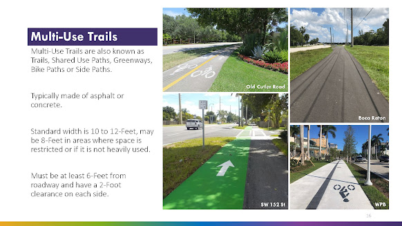
·       Standard width is 10 to 12-Feet, may be 8-Feet in areas where space is restricted or if it is not heavily used.
·      
Must be at least 6-Feet from roadway and have a 2-Foot clearance on each side. 
(See below)


SPACE REQUIREMENT: That means total space dedicated to the Multi-Use Trail would be 16 to 20 feet from the edge of the roadway [minimum 6 feet from road, plus minimum 8 feet (where restricted) plus an additional 2 feet of clearance from the edge of the path furthest from the street].

IMPORTANT ISSUES: The logical question here is whether there is sufficient open right of way along Coral Reef Drive? I have previously identified the numerous mature shade canopy trees as well as a historic coral rock wall in many areas.

My issue is what trees will be destroyed for a project that may not fit within the design parameters set by Marlin Engineering? Or would the Coral Reef Multi-Path be forced to take the same type of modifications used on SW 136 Street such as severe reductions or splitting the path in two to allover for trees in a center median?

The discussion above leads to many fair questions to be discussed when and if these proposals come before the mayor and village council. That is, unless any changes would be handled administratively as attempted (and, thankfully, denied) for the Palmetto Bay Village Center.

Applying the Marlin Engineering Design recommendations to the actual 136 Street buildout:

Obviously the SW 136 Street Multi-Path was not designed by Marlin Engineering as that path does not conform to the design criteria.  There are many areas where the 136 Street path is significantly less than 8 feet, some areas only as wide as the standard sidewalk they sought to upgrade from. There are many areas where the SW 136 Street path is significantly closer to the roadway than the 6 feet Marlin Engineering’s design recommends. That same 136 Street path also suffers many areas where the path has a hard end to obstructions including fences, walls and hedges – meaning there is no 2 foot buffer for the non-street side of the path – any bicyclist attempting to use the path would need to stay to center in order to avoid conflicts with these obstructions, thus severely reducing the effective width of that area of the path.

Background - prior related post - see: January 28, 2022, Next issue - do we turn Coral Reef Drive into the next SW 136th Street? Time to get involved.

TO BE CONTINUED ... stay tuned and check back for updates

Monday, October 18, 2021

UPDATE: Series on Multi Paths - looking at the Red Road Linear Park Path. How it compares to the Palmetto Bay designed 136th Street project.

This video is part of a series examining multi use paths in our area. I plan in comparing the Old Cutler Trail, the Cutler Bay Shared use path, the Pinecrest Red Road Lineal Park Path. All compared with the current Palmetto Bay designed Shared Path now under construction on SW 136th Street. 

Many of you may be familiar with this Red Road Linear Park Path. It was originally created under Miami-Dade County and later nurtured and maintained by the Village of Pinecrest. Compare it with the JPA shared path that Palmetto Bay designed for SW 136th Street.

The Red Road Linear Park Path is a 2.5 mile lighted walking/bicycle path along the Snapper Creek Canal on Red Road. There are three rest areas accented with coral rock walls and enhanced landscaping along historic Red Road, located along the East-side of Red Road between Kendall Drive and Killian Drive in Pinecrest, Florida.

Now this is a shaded, park type amenity that provides safe mobility!

Here is a Yelp Review of this path/park:

Yes, per the Village of Pinecrest, this does qualify as parkland. It's a little strip of land bordered by Red Road on one side and the Snapper Creek Canal on the other. There is a meandering paved path, one upon which my running feet pound quite often. It's a running/walking/biking/blading path, and a good one.

The park is listed as 2.5 miles long. I'm surprised at that, because my internal odometer says it feels a little less. Maybe that's because unlike many other South Florida "parks," it actually has a bit of a tree canopy, helping somewhat to ease the pain the sun brings. In fact, there's a wide variety of native plant life on display along this path, from gumbo limbo to cypress to pond apple. This helps make the path as scenic as a path that close to a busy road can be.

This stretch of Snapper Creek looks like an enticing place to cast a fishing line, but in all honesty, the fishing here sucks. This stretch of the canal is just a deep featureless ditch, with little or no aquatic plant life or other structure providing cover for fish.

Insider tip....only run here when the wind is out of the east, the path is on the east side of Red Road. Run here during periods of westerly breeze, and you open yourself up to breathing truck exhaust.

Important note - this is one multi use path where there are no potential conflicts with motor vehicles - not one. At no point do vehicles cross the path at any point along any of this 2.5 mile path.

Take note of the following for this Red Road Linear Park Path:

  • The appearance of park amenity including numerous park type benches. The uniformity of the path.
  • The quality of the construction.
  • There are no areas of conflict with cars anywhere along the entirety of the 2.5 miles of this path. It is a path uninterrupted by any conflict from motor vehicles crossing the path. 
  • At no time does this path narrow from its uniform width, nor does it take any sharp turns or curves (once it begins – the southern terminus connects to the cross walk that leads to Pinecrest Gardens – and other path. 

Contrast this with the Palmetto Bay designed shared path. Note that there will be as many as 70 separate areas of conflict with roadways and the numerous driveways that will cross the Palmetto Bay designed shared path along SW 136th Street. And note, I have previously identified that safety is compromised at each point where motorized vehicles cross shared paths. 

See PRIOR RELATED POST of September 29, 2021, Series on Multi Paths - looking at Cutler Bay's shared path project. How it compares to the Palmetto Bay designed 136th Street project.

Friday, June 18, 2021

SW 136th Street Project update. Time for an honest discussion – the project designed by Palmetto Bay officials is hardly a bikeability project. It is comparable to the shared path along Old Cutler Road (OCR). I have several points to make here in this post.

The shared path designed for SW 136 Street by the present Palmetto Bay mayor and council is not a protected bike lane; it will function to the same extent that the Old Cutler Trail (OCR) is not a protected bike lane (OCR is a "Sharrow"). The 136 Street path will not be safe for cyclists who travel at fast speeds. Many of the cyclists who ride the road (as opposed to the share path) are travelling at speeds averaging 17 to greater than 25 MPH. Those speeds to not mix well with joggers, pedestrians, children, dogs or golf carts that will also be using a shared path (hence the name - "shared path")

Too few are willing to acknowledge that the bicycle is legally defined as a vehicle and the bicyclist is a driver under the Laws of the State of Florida (see Florida Statutes, Chapter 316.2065 Bicycle regulations.—). Bicyclists have the same rights to the roadways, and must obey the same traffic laws as the drivers of other vehicles. These laws include stopping for stop signs and red lights, riding with the flow of traffic, using lights at night, yielding the right-of-way when entering a roadway and yielding to pedestrians in crosswalks. 

Please note that this post is a bit technical, but it needs discussion as there are big issues that I see when looking at the current rendering for the SW 136th Street project is where does Palmetto Bay account for the cyclist on the roadway? The cyclists are missing. Why? Are Palmetto Bay officials wishing them away? These needs to be room for the cyclists and, more important, proper room for allowing safe passage around cyclists as the law is clear, 3 foot buffer required when passing:

The driver of a vehicle overtaking a bicycle or other nonmotorized vehicle, or an electric bicycle, must pass the bicycle, other nonmotorized vehicle, or electric bicycle at a safe distance of not less than 3 feet between the vehicle and the bicycle, other nonmotorized vehicle, or electric bicycle.
See: Florida Statutes 316.083 (1) (Bold emphasis added)

Issues that I have found with shared paths: Predictability is a huge factor in preventing accidents. Drivers look for the oncoming motor vehicles before they make turns. Cyclists on a multi-path are often far from the focused field of vision for motor vehicle drivers, especially if the cyclist is riding on a multi-path in a direction that is counter to the direction of the lane it is adjacent to (e.g. riding southbound on the Old Cutler Path, which is adjacent to the north bound lane of traffic on Old Cutler Road). Cyclists are often obscured by these vehicles and have moved into the path of the vehicle by the time the oncoming traffic has cleared.

The bottom line is that a multi-path is not a protected bike lane and anyone who thinks these paths are “safer” than bike lanes are fooling themselves (and putting people at risk). 

The sad part is that I can already hear the angst by motorists, yelling in frustration at these cyclists to ‘get onto the sidewalk that taxpayers paid $$$ millions for, but that cyclists refuse to use.” Facts are facts. Cyclists are legally allowed to use the road (Florida Statutes, Chapter 316.2065) and motorists are legally required to pass cyclists allowing for a 3 foot buffer.

It is too bad that current Palmetto Bay officials have failed to hold a public, open and frank discussion of these issues. Unrealistic expectations may have been set. 

SPECIAL NOTE: Look to the 3 areas I have circled in red (photo above). Moving from left to right, the first two circled areas are missing the anticipated cyclists. Will there be room for vehicles to pass safely, providing for the legally required 3 foot buffer? The 3rd area circled is equally concerning. 8-10 feet of shared path is alleged, but there does not appear to be sufficient room for cyclists and pedestrians to co-exist. Is this official rendering not to scale?

Wednesday, June 24, 2020

Yet another car v bike conflict along the Old Cutler Trail – a multi-use path, not a dedicated bike lane.

I have personally witnessed numerous motor vehicle v. bicyclist accidents along the Old Cutler Trail - accidents at the entrance of Thalatta Estate, the library and at the commercial strip just north of SW 168th Street (where the 6/24/2020 incident occurred). Drivers are watching for cars on the roadway. Pedestrians can stop with the next step, but cyclists travelling anywhere from 12-20 MPH cannot.


Palmetto Bay Police 4 units and MDFR Truck 62 responded to a cyclist struck along Old Cutler Road, just north of SW 168th Street. The Cyclist was using the multi-path - known as the Old Cutler Trail

The Old Cutler Trail is not a protected bike lane. Too few are willing to acknowledge that the bicycle is legally defined as a vehicle and the bicyclist is a driver under the Laws of the State of Florida (see Florida Statutes, Chapter 316.2065 Bicycle regulations.—). Bicyclists have the same rights to the roadways, and must obey the same traffic laws as the drivers of other vehicles. These laws include stopping for stop signs and red lights, riding with the flow of traffic, using lights at night, yielding the right-of-way when entering a roadway and yielding to pedestrians in crosswalks. 

Predictability is a huge factor in preventing accidents. Drivers look for the oncoming motor vehicles before they make turns. Cyclists on a multi-path are often far from the focused field of vision for motor vehicle drivers, especially if the cyclist is riding on a multi-path in a direction that is counter to the direction of the lane it is adjacent to (e.g. riding southbound on the Old Cutler Path, which is adjacent to the north bound lane of traffic on Old Cutler Road). Cyclists are often obscured by these vehicles and have moved into the path of the vehicle by the time the oncoming traffic has cleared.

The bottom line is that a multi-path is not a protected bike lane and anyone who thinks these paths are “safer” than bike lanes are fooling themselves (and putting people at risk). The accident today is not an uncommon occurrence. In fact, many are slight conflicts (thankfully) and therefore are not even reported.

Wednesday, December 30, 2020

Really? 18.4 miles of MEGA sidewalks planned for Palmetto Bay? Look what our local officials have placed in the 2045 County Master Plan.

What a difference a change in leadership makes. Have you viewed the September 2019 Miami-Dade County 2019 updated to the County Bicycle Pedestrian Master Plan? If not, it may be time as many of these projects are slated for completion by 2023 and we are now entering 2021.

The short term projects still allege 4 foot wide bike lanes totaling 3.6 gross miles. But note the areas slated to receive 8 foot wide (MEGA) path - a total of 18.4 miles of MEGA sidewalk are slated for the areas indicted on the excerpt posted below. 

94 AVE - SW 175 ST to SW 184 ST    Install 8' wide multi-use path 0.5 gross mile
160 ST -  SW 164 ST to SW 89 AVE Install 8' wide multi-use path 1.5 gross mile 
141 ST  - SW 87 AVE to SW 175 ST Install 8' wide multi-use path 2.4 gross mile
152 ST  - SW 85 AVE to SW 151 ST Install 8' wide multi-use path 0.7 gross mile
77 CT    - SW 139 TER to SW 57 AVE Install 8' wide multi-use path 3.9 gross mile 
87 AVE - SW 79 AVE to SW 79 AVE Install 8' wide multi-use path 1.3 gross mile
135 ST - Old Cutler Rd to SW 184 ST Install 8' wide multi-use path 3.5 gross mile 
152 ST - SW 72 AVE to Old Cutler Rd Install 8' wide multi-use path 1.2 gross mile
Old Cutler Rd - 135 ST to SW 184 ST Install 8' wide multi-use path 3.4 gross mile

That's a lot of 8 foot wide MEGA paths paving through Palmetto Bay. 
Did you receive a survey asking your opinion? 
Were you invited to participate in a Town Hall meeting to discuss these planned projects?

CLICK HERE to review the two pages specifically referencing plans for Palmetto Bay (2 pages).

CLICK HERE to view the full document (256 pages) the 2045 Miami-Dade Bicycle Pedestrian Master Plan, September 2019

The Palmetto Bay Priorities are listed beginning online .PDF page 52. See figures 19, 20 and 21, all posted below. 

FIGURE 19 PALMETTO BAY SHORT TERM PRIORITIZED PROJECTS

FIGURE 20 PALMETTO BAY MID TERM PRIORITIZED PROJECTS

FIGURE 21 PALMETTO BAY LONG TERM PRIORITIZED PROJECTS

Here are my questions:

Where are the 8 foot mega sidewalks shown in the update (2019) County Plan referenced in the current Palmetto Bay Bicycle and Pedestrian Master Plan  adopted in 2019 with significant public involvement?

When did Palmetto Bay officials transmit to the County that Palmetto Bay was in agreement with the proposed mega sidewalks as referenced in figures 19, 20 & 21, as provided above?

When and how did the current Mayor and Village Council Members involve or even notify the public, particularly those who will be most affected by the MEGA sidewalks.

Wednesday, September 29, 2021

Series on Multi Paths - looking at Cutler Bay's shared path project. How it compares to the Palmetto Bay designed 136th Street project.


This video is part of a series examining multi use paths in our area. I plan in comparing the Old Cutler Trail, the Cutler Bay Shared use path, the Pinecrest Red Road Lineal Park Path, all with the current Palmetto Bay designed Shared Path now under construction on SW 136th Street. 

Part 1. Please look at this shared use path that Cutler Bay worked on with Miami-Dade County and compare it with the JPA shared path that Palmetto Bay designed for SW 136th Street.

Take note of the following for this Cutler Bay designed shared path:
  • The appearance of park amenity including numerous park type benches. The uniformity of the path.
  • The quality of the construction.
  • There are minimal areas of conflict with cars - in fact, there are no conflicts in the first 1 minute, 46 seconds of this video. The distance is .4 of a mile or 2,116 feet (measured via Google Earth) where there is a path uninterrupted by any conflict from motor vehicles crossing the path. 
  • There are a total of 17 areas of potential conflict (after the .4 mile area mentioned above). There are few streets; most are business driveways all located in close proximity to the Franjo Road business district.
  • At no time does this path narrow from its uniform width, nor does it take any sharp turns or curves. 
Contrast this with the Palmetto Bay designed shared path. Note that there will be as many as 70 separate areas of conflict with roadways and the numerous driveways that will cross the Palmetto Bay designed shared path along SW 136th Street. And note, I have previously identified that safety is compromised at each point where motorized vehicles cross shared paths. 
Above and below, photos depicting the construction status of the Palmetto Bay designed shared path on SW 136th Street. Some landscaping will eventually be restored, but the widths will not change. The first photo shows a full 10 foot section that reduces to an 8 foot wide section. The other photo above shows a section where 8 feet is suddenly reduced to a mere 5 feet (standard sidewalk width). The photo below documents a section "separated" by mere feet and no curbing from SW 136th Street.

Please also note that there was no public input on the Palmetto Bay designed shared path. Not a single public meeting. The re-design was developed in private by a few people with special influence and who enjoy special access to the current mayor.
Reference materials. See prior related posts of:


And yes, in the interest of full disclosure, I am a cyclist and I am quite disappointed that this Palmetto Bay designed shared path will not get the cyclists off the road - that would require designation bike lanes - once designed for this SW 136th Street. See: June 22, 2021, Palmetto Bay can change the project, but municipal officials cannot change State Law which determines where bicyclists may ride. 

In other words, drivers will still be required to share SW 136th Street with cyclists. Please don't yell at the cyclists to move off the road. The fault is that of the current Palmetto Bay mayor and council who changed the plans from dedicated bike lanes to a shared path.

Sunday, October 24, 2021

Special post - Video of the day. The Old Cutler Trail: a shared path. Would you walk or ride through a loading zone? No. But then why would you use a shared path as an unloading zone? Is there any enforcement?

Another day, another violation on a shared path in Palmetto Bay. This is a safety issue.

I ask you, would you allow children to walk or ride bikes and scooters around trucks in a loading zone? Of course not. Then why would you allow multi-paths to be used as a parking/unloading zone, especially at a time and on a day when you expect children to be riding this shared path?
This is yet another example as to why I fight for bike lanes, not shared paths. Multi-paths are too easily misused by vehicles for either parking or even driving. And please, I've heard that I should call the police, not post on social media. Not buying that. I'm out riding, not patrolling. We have police patrolling. In my opinion, this is a clear and obvious violation of the multi-path (no motorized vehicles) as well as an affront to the ADA. You want shared paths? Then enforce rules that make paths safe. It is not up to cyclists to police the paths like a pack of 'boomer Karens'. The SW 136th Street Path is not even complete and already … it’s a parking space! Seen on SW 136th Street on Friday, October 1st, 2021. Hey, Sue, I guess the cyclists have more room in the lane when the cars 'take the path'! See: October 2, 2021, Special post - Photo(s) of the day. Reader submitted photos of the Palmetto Bay designed shared path. Or is it a car park?

Monday, September 21, 2020

Update on the MEGA Multipath slated for Howard Drive (Palmetto Bay side only). The colors really do bring out the contrast. (an update in a series)

Is this MEGA path needed? Has anyone ever told you that they would love to go for a walk along SW 136 Street, but said they couldn’t because the existing sidewalk is too narrow?  (NOTE - this POST WAS UPDATED 9/22/2020 at 10:15 AM) 

There is a standard sized sidewalk that runs from US1 all the way to Old Cutler Road.  Who asked for this multi-path and what will it really look like? 

The plans are tough to read, so I asked for someone to use color to fill in the sidewalk and the planned MEGA path to provide prospective. The blue marks the existing standard size sidewalk. The color orange is used to mark where these plans have the MEGA sidewalk placed for the home at 8100 SW 136 Street. Note that for this home, the sidewalk is not a 4 foot extension of the existing, but a complete 8-10 foot new creation that is a full 10 feet or more closer to the existing home. This path is not straight, it meanders, meaning that the impact will not be the same (will not be uniform) for all the homes that front Howard Drive. Some may hardly notice it, but some homes will have a HUGE impact, you might say a MEGA impact.

Sources tell me that there is a grand Photo Op ceremony set for Friday, October 2nd (the last day of the current Interim Manager who put in notice of his resignation on Monday, September 21, but that was a prior story.)


9/22/2020 update: I have a section for the area adjacent and in front of Howard Drive Elementary School - see updated pic below:

Note how the path curves with the radius of the intersection like a sidewalk, unlike a bike lane. Does the radius at the Southwest corner of 136/77 foreshadow a future project, extending the concrete MEGA path to eventually travel South along 77th Avenue to Coral Reef Park?

Does the MEGA Path also curve into 82nd Avenue at the intersection of 136/82 and, if so, which side of 82nd Avenue will the continuation of this path travel down?

FAIR QUESTION: If this path is so great, so safe, then why did Pinecrest pay more money so this project would be pushed off, out of Pinecrest and solely onto Palmetto Bay residents?

THE TOOL BOX: CLICK HERE to view related past posts relating to the dismantaling of the bike lanes and substituting them with the Howard Drive MEGA PATH. 

Friday, March 5, 2021

The Old Cutler shared multi-path. It is not a lane for motor vehicles. 2/19/2021 - Sidewalk Driving - Old Cutler Road (N to 152nd St.)

Wow, do not try this at home! Dangerous driving that, in my opinion, places any of the people who properly use the shared multi-path along Old Cutler Road at great risk of bodily harm or worse:

The shared path is NOT a turbo lane and should not be used for driving. The shared path is used by walkers, joggers (including strollers and dogs on leashes), cyclists (along the properly maintained sections when there is room).  the Palmetto Bay Village Council also approved a resolution calling on the County to approve the use of small motorized vehicles - in this case golf carts - to also use the shared path.

You can skip to 0:50:00 (50 seconds) to get to the point of the video.


 I wonder if traffic allowed this driver back in or did the attempted reentry lead to more conflict.

A great illustration of the term "stay in your lane".

Friday, November 8, 2019

Time is past due for a Public Meeting to engage and update residents regarding the SW 136th Street Project

Transparency and public involvement matters to those Elected Officials who want their fellow residents to trust their government. Residents should be able to expect transparency from their elected officials.

The time is long past due for our elected officials to update and involve our fellow Palmetto Bay residents on the Howard Drive "bike lane" project.  As background, please review  a PRIOR RELATED POST of January 25, 2017: Update on the 136 improvement meeting held at Howard Drive Elementary & Temporary Traffic Tables coming to Farmers Road during County Pilot Program. Significant information was provided then and an update is long overdue, especially as the wheels appear to have come off the tracks for this project.  Transparency counts.

People who feared loss of trees for a simple bike lane will now face a much greater impact from a 10 foot 'multi-use path' (a/k/a a MEGA sidewalk) in front of their homes (OK, I understand that the MEGA sidewalk may be reduced a 'mere' 8 feet in some sections). Regardless, there will be much less room to park without violating the ADA by parking on a sidewalk. There will be significantly less room for trees. 

I am waiting to see how this MEGA sidewalk impacts the 136th Street student drop off in front of Howard Drive Elementary.  We need answers.

What happened to this project?  Other important questions include: 
  • Did any of our village council members work to change out the agreed to bike lanes to a 10 foot MEGA path placed solely on the Palmetto Bay side? And, if so, why wasn't the public updated. 
  • Or were they caught unaware? 
  • Why weren't our residents consulted in advance of this major change, did our representatives not know, or do their voices not matter? 
  • Is the MEGA path a 'done deal' or can our residents still have input? 
  • Which residents were provided inside knowledge and if so, why were other concerned residents neither not invited to meetings or at least provided a timely update?
And still, the current Palmetto Bay Mayor and other officials still remain unaware, or unwilling, to update the facts of the project as the Village Website continues to incorrectly mislead the readers that the "136th St. Improvement Project remains as follows:
136th St. Improvement Project
This project is currently under design. Improvements include minor widening of the roadway to add bike lanes on both sides of the road and milling & resurfacing the existing roadway. We are looking to replace the existing 5’ sidewalk on the South side of SW 136TH Street (Village of Palmetto Bay Side) with a new 7’ wide sidewalk. Other improvements will include pavement markings, ADA Compliant pedestrian ramps, and landscape improvements. This is a LAP Project between Miami Dade County and FDOT, and Village of Pinecrest and Village of Palmetto Bay are also stakeholders.
(this is how the web notice reads as of 3:00 PM, Friday, Nov. 8, 2019)
CLICK HERE if you want to see if the website has been altered as a result of this blog post.
Screen shot taken 2:35 PM, 11-8-2019
Do you want to see what a 10 foot MEGA Multi-Path looks like? Please see a PRIOR RELATED POST of January 13, 2019, Taking a close look. A ten foot multi-use path proposed for around Palmetto Bay by a member of the Village Council - here is how it might look. Actual photos of a similar, if not identical design. Offering some Pros & Cons
Will this be the new look for the Palmetto Bay side of Howard Drive?

 Other PRIOR RELATED POSTS of interest - part of your tool box of information relating to this process:

October 30, 2019, Pinecrest Wins, Palmetto Bay loses. Pinecrest Council discusses material changes to 136 St Bike Lane. Palmetto Bay may be home to a 10 foot MEGA sidewalk instead of a shared project.

EDITOR'S NOTE - There was no update on this project was provided (at least to the public) at the Palmetto Bay regular village council meeting of November 4, 2019. Why not?

October 29, 2019, Foreshadowing - for now, please review the Palmetto Bay Path conceptual Plan proposed by Marsha Matson, Palmetto Bay Councilmember, District 3, March 18, 2019.

I will place any updates here when the long-overdue public input session is set and noticed. This blog has a way to nudge Palmetto Bay into action.

Eugene Flinn

Sunday, January 13, 2019

Taking a close look. A ten foot multi-use path proposed for around Palmetto Bay by a member of the Village Council - here is how it might look. Actual photos of a similar, if not identical design. Offering some Pros & Cons

Discussion is ongoing between the Village Council members regarding a 10 foot wide multi-use path around Palmetto Bay.  Many residents are unaware of how serious this proposal is as this proposal was last discussed at a "Visioning" session held on a Saturday morning (January 12) where only 3 members of the public were present.  The meeting was not broadcast on WBAY or live streamed.  

The issue of public participation and notice of meetings is another discussion for another time. 


This present blog post is about wide sidewalks and what they will look like here in Palmetto Bay. I have posted aerial and street level photos below showing a 10 foot multi use path in a residential area. The area is SW 87th Avenue and Miller Road area. 


Is this what councilwoman Marsha Matson is proposing for Palmetto Bay? 


Please note this post is informational in order to discuss, not attack, the proposal. There are pros and cons to this proposal, as in most any ideas.  I discuss some of the issues below.


How would  such a path look, running alongside either SW 184th or SW 136th Streets? Along US1, would vehicles pulling out of stores and shopping centers stop before entering these paths or will they continue through to the edge of the road where they would block the path or worse, could plow into any bicyclists riding on the path?

Would your opinion change about such a path when advised that bicyclists would not be legally required to use such a path instead of the roadway?

Note:  This is just one way such a path could be completed. Perhaps softer walkways, such as used in paths at the park are prepare, though paths such as the one proposed for surrounding Palmetto Bay would certainly be subjected to much heavier, constant use including trucks and cars that would be driving over it to enter or exit properties.

          PROs / CONs

Pros: Nice wide sidewalk that services multiple uses including pedestrians, joggers, walkers with strollers, dogs, accompanying children in pedal cars or small trikes, as well as some slow moving cyclists.

Cons: Bicyclists competing with pedestrians, moving in same direction as the pedestrians or other users identified above. 

Cons for property owners:  That's a lot of cement in front of homes and/or businesses. Much more green space/drainage swale is taken up than simple bike lanes.

Additional cons specific to cycling: Bicyclists are vehicle drivers, they belong on the road… and they are safer on the road. This type of path discourages use by cyclists as, unlike the street or bike lanes, the route is constantly undulating due to the driveway curb cuts.   

Adult bicyclists do not belong on the sidewalk. Riding on the sidewalk is unsafe for cyclists and pedestrians. Cyclists on the sidewalk expose motorists to a higher risk of hitting them when entering or leaving the road — where the motorists are likely to be at fault in such a crash.

          FLORIDA LAW RELATING TO BICYCLES:

In Florida the bicycle is legally defined as a vehicle and the bicyclist is a driver. Bicyclists have the same rights to the roadways, and must obey the same traffic laws as the drivers of other vehicles. These laws include stopping for stop signs and red lights, riding with the flow of traffic, using lights at night, yielding the right-of-way when entering a roadway and yielding to pedestrians in crosswalks. 

Wednesday, October 30, 2019

Pinecrest Wins, Palmetto Bay loses. Pinecrest Council discusses material changes to 136 St Bike Lane. Palmetto Bay may be home to a 10 foot MEGA sidewalk instead of a shared project.

Residents who live along SW 136th Street - prepare yourself for a 10 foot MEGA sidewalk (a/k/a 'multi-use path) to be placed in front of your homes.  The other shoe has dropped - and this one falls very loudly, with great impact. Far too many, if not all Palmetto Bay residents, will learn of this months old change to the project for the first time here on this blog post, rather than directly from their current elected officials. That is a shame. Please view the video posted below for the important information. I can add little over the statements and cackling contained in this video. It is a much watch and it may change your opinion of how those in our neighboring municipality view their neighbor to the south.

And to add insult to injury, Palmetto Bay residents - get ready to spend over $500,000 of our own tax dollars to relieve Pinecrest of its shared burden on this bike lane project. And apparently, no residents were ever consulted regarding this change in project. If they were, they were insiders with special privileged access. 

Let me preface some of my remarks with the statement that when I was Mayor, I kept a close eye on projects such as this Howard Drive Bike Lane Project, so I am not buying into any defense from the current Mayor and Palmetto Bay Council that they were unaware.  The Pinecrest Council even discussed that this matter was to be discussed at a Chamber South Transportation Meeting (was Palmetto Bay represented at this meeting?). The Mayor indicated that this project had been changed to the 10 foot multi-path months earlier. Palmetto Bay is not advising its resents, in fact, the village website continues to describe the project as follows:
This project is currently under design. Improvements include minor widening of the roadway to add bike lanes on both sides of the road and milling & resurfacing the existing roadway. We are looking to replace the existing 5’ sidewalk on the South side of SW 136TH Street (Village of Palmetto Bay Side) with a new 7’ wide sidewalk. Other improvements will include pavement markings, ADA Compliant pedestrian ramps, and landscape improvements. This is a LAP Project between Miami Dade County and FDOT, and Village of Pinecrest and Village of Palmetto Bay are also stakeholders.
The above was the Palmetto Bay project description as of 11:00 AM, October 30, 2019.

There is so much more to being an elected official than selfies and trying to break records for the number of proclamations that can be awarded.  

Protecting your residents from having to shoulder 100% of a joint infrastructure project is one such example. People who feared loss of trees for a simple bike lane will now face a much greater impact from a 10 foot 'multi-use path' (a/k/a a MEGA sidewalk) in front of their homes.  There will be much less room to park without violating the ADA by parking on a sidewalk. There will be significantly less room for trees. And I am waiting to see how this MEGA sidewalk impacts the parking and 136th Street parking and student drop off at Howard Drive Elementary.

I knew how the (then) planned bike lanes would impact, or how we could and would mitigate impacts to neighbors at all times while I was mayor. Does current Mayor Cunningham have the insight for this material change? If so, when were we to be advised? Monitoring the project and actually delivering on the promises are even more important that the conceptualization. 

It appears that this current Palmetto Bay Council fail to read and understand their agenda; what they are voting on. (See prior post, link far below)

And now we see what happens to our residents when the same members of the Palmetto Bay Village Council fail to follow up and monitor projects in development.

How did the Pinecrest Council react? View for yourself. What bothers me the most as a Palmetto Bay resident? What I perceive to be the sheer glee exhibited by some of the Pinecrest Council which you can see at minute one of the video when the Pinecrest Manager reveals that the entire shared path is actually going to go on the Palmetto Bay side. The entire Pinecrest Village Council erupts in laughter that seem to indicate to me that they are relieved their community is now off the hook. 

“Excellent!” is the excited utterance of Pinecrest Vice Mayor Anna Hochkammer (at 1:11) when discussing how the project is entirely withing Palmetto Bay. 

Then there is what I feel to be a somewhat caustic comment at one minute, 11 seconds, “…those guys cannot organize a two car motorcade - they're going to screw this up." Is this comment direct to Miami-Dade County or Palmetto Bay? Decide for yourself.

Don't just take my word for it. See and hear for yourself:
00:00:37 Pinecrest Manager explained that the issue is that County has analyzed SW 136th Street - trees are going to be an issue. (Editor’s comment: Not for Pinecrest, but now only an issue for Palmetto Bay) 00:01:00 – Pinecrest Manager reveals that the entire shared path is actually going to go on the Palmetto Bay side [Laughter erupts and ensues amongst the entire Pinecrest Village Council – “Excellent!” – Pinecrest Vice Mayor Anna Hochkammer ( 1:11 )] 00:01:11 Impolite comment: “…those guys cannot organize a two car motorcade - they're going to screw this up." (Editor's Comment: does this refer to Miami-Dade County or Palmetto Bay?) 00:01:19 Pinecrest council discussed "pulling their million dollars back" - "It's now in Palmetto Bay, it's never going to happen" Redesign was created (1:45:30). 00:02:50 Pinecrest Council discussion, confirming that the County Commissioner is involved. 00:03:05 Mayor Corradino discusses bringing this project up for discussion at the Friday, Chamber South Transportation Committee (this would have been Friday, October 18, 2019). Pinecrest Council debate goes on in regard to staying involved as it will never happen if it relies upon Palmetto Bay alone. 00:03:15 One Pinecrest Councilmember asks a ‘legitimate question’ – why is Pinecrest paying $1 million when this project is now fully on the Palmetto Bay side? 00:04:05 Pinecrest Council in discussion, that they cannot pull out, the project will never get done if they do. 00:05:08 Discussion of Traffic Control devices on Old Cutler Road – preliminary plans were to include up to 2 traffic circles as part of the program 00:05:40 Note the discussion in Pinecrest on control over the art for the traffic calming - Pinecrest will control. (mocking Palmetto Bay’s past choices). Pinecrest Manager talks about how she pushed back with Palmetto Bay to maintain Pinecrest’s choice / control as a requirement of Pinecrest’s participation. 00:06:07 (to 6:26) Pinecrest Council laughing at the loss of Palmetto Bay Village Manager - mocking Palmetto Bay's Manager situation. 00:06:54 Pinecrest Manager states that the County has committed to new construction plans by February (2020) 00:07:30 Mayor mocks Palmetto Bay - "Wait till you tell Palmetto Bay, then all hell will break loose in Palmetto Bay because they (PBay) are doing something" (7:38) End of discussion on this topic – the meeting moves on to the remainder of the agenda.

RELEVANT MATERIALS - THE ISSUE 'TOOL BOX':

See prior posts of January 13, 2019, Taking a close look. A ten foot multi-use path proposed for around Palmetto Bay by a member of the Village Council - here is how it might look. Actual photos of a similar, if not identical design. Offering some Pros & Cons

October 29, 2019, Foreshadowing - for now, please review the Palmetto Bay Path conceptual Plan proposed by Marsha Matson, Palmetto Bay Councilmember, District 3, March 18, 2019. and

October 28, 2019, Village Council Chaos - Interaction with Village Attorney at a council meeting - Village Mayor & Council: You have been told repeatedly. You are the voting body. You have responsibilities of reading and knowing what you are voting on.

Saturday, March 19, 2022

Marlin Engineering provides guidance on a proper shared path. This is important for Coral Reef Drive & 184 – and the specifications demonstrate that the 136th Shared Path is more a mess than a safe path – important details.

Do it right, or don't do it at all. The current mayor and this council should not repeat the mistakes made in redesigning the SW 136th Street project. The photos at the bottom serve to shine light on poor planning and defines the term forcing a square peg in a round hole - who is really happy with SW 136th Street? The results really do not fit in this particular place or situation. 

Important point: There is no legal requirement to make profound changes to either SW 184 or Coral Reef Drive - so the Palmetto Bay mayor and council should resist temptation to spend the tax dollars, unless the project brings quality improvements to those streets. Don't sacrifice historic coral rock walls and magnificent shade and clean air producing canopy trees to a vanity project.

The first question is whether a shared path properly fit in the existing street right of way.  This Coral Reef / 184 project is not one of a pre-planned area. These areas will require significant work arounds due to many existing obstacles such as power poles, coral rock walls and many, many historic trees. Marlin Engineering* has provided recommended specifications regarding a proper shared path (see figure and description posted below). This is important for Coral Reef Drive & 184 – and the specifications demonstrate that the 136th Shared Path is more a mess than a safe path – important details.

The following is the Marlin Engineering planner's specifications contained in slide 16.

  • The standard width is 10 to 12-Feet, may be 8-Feet in areas where space is restricted or if it is not heavily used.
  • The path must be at least 6-Feet from roadway and have a 2-Foot clearance on each side.

See Page/slide 16 of the Multi-Use Trail & SMART Plan Connectivity Study, Bicycle & Pedestrian Advisory Committee Meeting, November 16, 2021

Why is the above important?

Because here are some photos taken of the SW 136th Street path where you can clearly see significant portions of the path where these important guidelines are not met:


Observable issues (above). The path at these points are neither 6 feet from the roadway nor is there the stated recommended two feet clearance on the other side (backs up to a thick hedge - you can see why that would be a problem when dealing with handlebars, etc.)

Immediately above and below - there is no explaining splitting the path into two separate 4 foot sections. Does it really equal a useable 8 feet? Is the sidewalk traffic really that bad that Palmetto Bay officials feel the need to created a divided pathway to separate oncoming users? There is no 2 foot buffer to the inside portion as well as a lack of 6 feet buffer from the street. The only way to describe this is the useable swale area (water runoff) and resident/guest parking is gone, essentially the entire right of way has been paved over.


Above - twisting and turning with an abrupt reduction from 6-8 feet to a standard 5 foot sidewalk, clearly not within the Marlin Engineering guideline.

Below - where is the safety buffer from traffic? Cars can and will easily pull off the road and onto the pathway, placing users at risk.

CLICK HERE to view prior related posts on shared paths including 136th Street, Red Road and Old Cutler Road, both in Palmetto Bay as well as in Cutler Bay.

*Marlin Engineering is facilitating Palmetto Bay's Multi-Use Trail & SMART Plan Connectivity Study