Showing posts with label Bike Lanes. Show all posts

Saturday, March 19, 2022

Marlin Engineering provides guidance on a proper shared path. This is important for Coral Reef Drive & 184 – and the specifications demonstrate that the 136th Shared Path is more a mess than a safe path – important details.

Do it right, or don't do it at all. The current mayor and this council should not repeat the mistakes made in redesigning the SW 136th Street project. The photos at the bottom serve to shine light on poor planning and defines the term forcing a square peg in a round hole - who is really happy with SW 136th Street? The results really do not fit in this particular place or situation. 

Important point: There is no legal requirement to make profound changes to either SW 184 or Coral Reef Drive - so the Palmetto Bay mayor and council should resist temptation to spend the tax dollars, unless the project brings quality improvements to those streets. Don't sacrifice historic coral rock walls and magnificent shade and clean air producing canopy trees to a vanity project.

The first question is whether a shared path properly fit in the existing street right of way.  This Coral Reef / 184 project is not one of a pre-planned area. These areas will require significant work arounds due to many existing obstacles such as power poles, coral rock walls and many, many historic trees. Marlin Engineering* has provided recommended specifications regarding a proper shared path (see figure and description posted below). This is important for Coral Reef Drive & 184 – and the specifications demonstrate that the 136th Shared Path is more a mess than a safe path – important details.

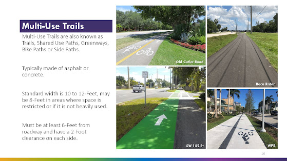
The following is the Marlin Engineering planner's specifications contained in slide 16.

  • The standard width is 10 to 12-Feet, may be 8-Feet in areas where space is restricted or if it is not heavily used.
  • The path must be at least 6-Feet from roadway and have a 2-Foot clearance on each side.

See Page/slide 16 of the Multi-Use Trail & SMART Plan Connectivity Study, Bicycle & Pedestrian Advisory Committee Meeting, November 16, 2021

Why is the above important?

Because here are some photos taken of the SW 136th Street path where you can clearly see significant portions of the path where these important guidelines are not met:


Observable issues (above). The path at these points are neither 6 feet from the roadway nor is there the stated recommended two feet clearance on the other side (backs up to a thick hedge - you can see why that would be a problem when dealing with handlebars, etc.)

Immediately above and below - there is no explaining splitting the path into two separate 4 foot sections. Does it really equal a useable 8 feet? Is the sidewalk traffic really that bad that Palmetto Bay officials feel the need to created a divided pathway to separate oncoming users? There is no 2 foot buffer to the inside portion as well as a lack of 6 feet buffer from the street. The only way to describe this is the useable swale area (water runoff) and resident/guest parking is gone, essentially the entire right of way has been paved over.


Above - twisting and turning with an abrupt reduction from 6-8 feet to a standard 5 foot sidewalk, clearly not within the Marlin Engineering guideline.
Below - where is the safety buffer from traffic? Cars can and will easily pull off the road and onto the pathway, placing users at risk.

CLICK HERE to view prior related posts on shared paths including 136th Street, Red Road and Old Cutler Road, both in Palmetto Bay as well as in Cutler Bay.

*Marlin Engineering is facilitating Palmetto Bay's Multi-Use Trail & SMART Plan Connectivity Study

Sunday, March 13, 2022

True bike mobility - examples of bike mobility options - see for yourself. What is your vision?

The video documents conventional bike lanes, pained bike lanes v protected bike lanes, as well as a shared path (where the roadway remains marked for shared use by bicyclists - identical to the Old Cutler Path).  This information is important as current Palmetto Bay officials are not satisfied with the SW 136th Street project - next up are other streets, including SW 184 as well as Coral Reef Drive - January 28, 2022, Next issue - do we turn Coral Reef Drive into the next SW 136th Street? Time to get involved.

 
Examples of different bike lanes - traditional (conventional) - along SW 62nd Avenue (in front of Miami's Community Newspapers) 0:01:42 Painted, traditional non-separated bike lane. 0:02:17 Sharrow and wide sidewalk 0:02:43 example of a curbed protected bike lane 0:03:38 another example of a curbed protected bike lane 
More to follow on bike lanes.

When you look, please consider what you prefer as a motorist as bike lanes are for drivers as well. How? Because a bike lane places the cyclists in their own lane, rather than taking the lane in front of the motorist. Remember, a shared path is not a dedicated bike lane. See December 17, 2018, Taking a close look - Old Cutler Bike Trail - designed use, rules of the road - Types of bikeways - 2 discussed here: paved path & sharrows. Cyclists may choose to use it, but is not required to do so - and there are many examples I can give as to why 'taking the lane' is preferable, and safer, for a cyclist than riding a shared path.

Also think about what you would prefer as a homeowner living on that street. Look to SW 136th Street to see the loss of swale (drainage, landscaping - green space) and parking. Does the SW 136th Street project get bicyclists off the roadway. In then end, the SW 136th Street is just a disjointed collection off standard size sidewalks in part with wider sidewalk  sections in other sections. Barriers remain in many areas including signage, abrupt curves as well as utility boxes and poles. It is neither well thought out or well designed.  See: October 2, 2021, Special post - Photo(s) of the day. Reader submitted photos of the Palmetto Bay designed shared path. Or is it a car park?

Another issue with projected bike lanes - what happens at time of deliveries - or garbage / recycling pick up? How are vehicles going to move down streets during these events? Delivery vehicles will remain in the street as they cannot pull off the road due to the barriers created for the protected bike lanes.  But at least no one will be parking on in the protected bike lanes (as they do on the shared paths) - the curbing or barriers prevent any such intrusion. 

We are seeing the impact of share paths in Palmetto Bay - far too many examples of vehicles parking on them as the right of way (swales) have been lost, so now where do guests or large families park? I have documented many such violations throughout this blog. So we need more?

This post is another in my series of relating to local issues, local places. This is part of a developing "taking a close look at" or "Fact Checking" series on issues and places in and around Palmetto Bay and our south Miami-Dade Communities.

Wednesday, February 2, 2022

Update on the Multi-Use Trail & SMART Plan Connectivity Study

The Multi-trails study is not listed on the agenda for the February Regular Council meeting.

I was advised that there has been an extension provided in order to finalize the draft report and conceptual plan sheets due to the latest COVID wave of Dec/Jan. Additionally, it is believed that there will be updated drafts that will be submitted to the Village, TPO and County in the next week or so. I will try to obtain and provide these documents in advance.

Perhaps this matter will go before the Village Council sometime in March. 

I am hopeful to receive a date, which I will pass on upon receipt.

CLICK HERE to view prior posts related to the Multi-Use Trail & SMART Plan Connectivity Study.


Monday, January 31, 2022

How and where will it all fit? Design definition of a multi-use trail – as defined by the Palmetto Bay study. Issues and concerns that should be addressed before any alternatives are greenlighted.

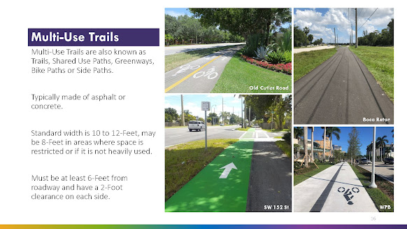
I have been asked to provide more information regarding the proposed multi-use trail, a possibility for Coral Reef Drive (and SW 184).  I have posted page 16 of the draft study below. Note this is limited to the multi-use trail, not the alternative plan if protected bike lanes were installed. The protected bike lane alternative will be the subject of a future post if there is interest from readers.

As indicated on page 16, for purposes of this study, Marlin Engineering lists the design (and impact) of a multi-use trail as follows:

·       Standard width is 10 to 12-Feet, may be 8-Feet in areas where space is restricted or if it is not heavily used.
·      
Must be at least 6-Feet from roadway and have a 2-Foot clearance on each side. 
(See below)


SPACE REQUIREMENT: That means total space dedicated to the Multi-Use Trail would be 16 to 20 feet from the edge of the roadway [minimum 6 feet from road, plus minimum 8 feet (where restricted) plus an additional 2 feet of clearance from the edge of the path furthest from the street].

IMPORTANT ISSUES: The logical question here is whether there is sufficient open right of way along Coral Reef Drive? I have previously identified the numerous mature shade canopy trees as well as a historic coral rock wall in many areas.

My issue is what trees will be destroyed for a project that may not fit within the design parameters set by Marlin Engineering? Or would the Coral Reef Multi-Path be forced to take the same type of modifications used on SW 136 Street such as severe reductions or splitting the path in two to allover for trees in a center median?

The discussion above leads to many fair questions to be discussed when and if these proposals come before the mayor and village council. That is, unless any changes would be handled administratively as attempted (and, thankfully, denied) for the Palmetto Bay Village Center.

Applying the Marlin Engineering Design recommendations to the actual 136 Street buildout:

Obviously the SW 136 Street Multi-Path was not designed by Marlin Engineering as that path does not conform to the design criteria.  There are many areas where the 136 Street path is significantly less than 8 feet, some areas only as wide as the standard sidewalk they sought to upgrade from. There are many areas where the SW 136 Street path is significantly closer to the roadway than the 6 feet Marlin Engineering’s design recommends. That same 136 Street path also suffers many areas where the path has a hard end to obstructions including fences, walls and hedges – meaning there is no 2 foot buffer for the non-street side of the path – any bicyclist attempting to use the path would need to stay to center in order to avoid conflicts with these obstructions, thus severely reducing the effective width of that area of the path.

Background - prior related post - see: January 28, 2022, Next issue - do we turn Coral Reef Drive into the next SW 136th Street? Time to get involved.

TO BE CONTINUED ... stay tuned and check back for updates

Friday, January 28, 2022

Next issue - do we turn Coral Reef Drive into the next SW 136th Street? Time to get involved.

Coral Reef Drive is one of our signature main streets crossing through Palmetto Bay. Do we really envision remaking this street into one where the mature canopy shade trees are yanked out for a concrete path of 8 to 10 feet? Ask yourself, what is the problem they are trying to solve as well as is this a case where the proposed 'solution' is actually worse than the problem they allege? Seriously, why would we want to change the character of Coral Reef Drive? I did not see any issue alleged in the recent survey put out by Village Officials, so do we really need to spend significant tax dollars to pour tons of cement along Coral Reef Drive, ripping out many, many, mature signature shade trees in the process?

All of the above should be discussed when an update of the Palmetto Bay Multi-Use Trail and SMART Plan Connectivity Study is scheduled to come before the Palmetto Bay Mayor and Council at the February Regular Council Meeting.

SPOILER ALERT: The recommendations to be presented to the Palmetto Bay Council represent profound changes to SW 184 and 152 Streets (those along SW 168th and 144th can rest easy - for now).

CLICK HERE to review the current document, consisting of 38 pages. As always, these documents are subject to change. I will update documents as I become aware of any.

IMPORTANT NOTE: There is no requirement for the mayor and council to make any changes to either Coral Reef Drive or SW 184th. This is all discretionary. "Keep as is" is an option. There is no compelling need to make changes to either road.

But for now, here is the issue for Coral Reef Drive:  Do you want to continue with Coral Reef Drive as it currently exists:

Is there really a problem with Coral Reef Drive as depicted in these photos? 

Or will the current mayor and council approve a change in scenery and go with the Howard Drive (SW 136th Street) model as seen below?

For perspective, comparing what is promised versus what is delivered, this is what was originally promised for SW 136th Street, as posted on the official Village Website as late as October 2021:


Then Village officials updated the SW 136th Street rendering to the following:

Actual photos of the 136th Street project disclose a much different reality:


All photos are actual photos, so we can see current conditions. The photos are fair comparisons.

Remember, this SW 136th Street project was once a bike lane project that would have extended the road surface a total of 8 feet; 4 feet on the Palmetto Bay side (east bound lanes) and the other 4 feet on the Pinecrest side (the west bound lanes) with minimal, if any impact on the existing tree canopy along Howard Drive. See related article of June 17, 2021: SW 136th Street update. There is no mistaking who owns responsibility for this SW 136th project design: Palmetto Bay officials (2019 to date) who redesigned it from bike lanes to a MEGA shared path.

Back to the current proposals being proposed for Coral Reef Drive:

The following have been taken from the current draft document. Note page 18, "SW 152 Street Existing Conditions". The street is characterized as a "Tree-lined residential Street" with a ROW (Right of Way) that varies from 73' - 96' feet. What is not detailed are sections of historic coral rock wall that exists within the ROW. See Page 18, posted below along with an actual photo of current SW 152 detailing the coral rock wall


BACKGROUND POSTS - CLICK HERE to view prior articles relating to share paths and the SW 136th Street project.

Excerpts from the present draft document. Please note the Pros and Cons presented. Feel free to formulate your own pro or con argument to the proposals:


TO BE CONTINUED ... stay tuned and check back for updates

Wednesday, December 1, 2021

Miami-Dade County DTPW sets a critical Virtual Public Meeting regarding the 87th Avenue bridge - set for December 15, 2021, from 6:30 p.m. to 8:00 p.m.

Miami-Dade County has scheduled the meeting Palmetto Bay officials have declined to have –a detailed public meeting on the 87 Avenue bridge. The advertisement is posted below. Miami Herald subscribers can view this Miami-Dade County advertisement on Page 12A, Miami Herald, Wednesday, December 1, 2021.

This meeting didn’t just pop up overnight. I am not sure why it was not discussed by the current mayor and council members at the Palmetto Bay Special Council meetings held Monday, November 29. Perhaps they were caught by surprise at the public notice in the Wednesday paper (although advertisement deadlines required that this advertisement be submitted days prior to the Monday meetings). Unfortunately, the current Palmetto Bay administration appears to prefer to restrict information rather than promote robust public discussions.

Regardless – who should attend? (I bet you, the reader, meets at list one of those listed below):

·       Those concerned (for and/or against) the bridge. 
· Cyclists who want input as to the planned dedicated bike lanes (including, not just for the bridge, but for all of 87 avenue). 
·       Those interested in connectivity for golf carts.
·       Pedestrians (who plan on walking this section – to see what protective walking areas the County has planned as they are not included in ‘dedicated’ bike lanes).
·       Those interested in ensuring that drought resistant native plants will be used for landscaping.
·       Those interested in this project adding value to the area (more than ‘just a bridge’ – the additional amenities).

Note the project will include lighting, fencing and landscaping - all of which will impact the immediate area.

Also note: This is a Miami-Dade County planned project, so we want to watch this project to ensure that it does not become another 136th Street MEGA sidewalk fiasco as planned by Palmetto Bay officials.

Also note - the planned amenities are those planned by Miami-Dade County and were never mentioned or sought by Palmetto Bay Officials during the many months of negotiations were held on the proposed Interlocal A

More information (for those who truly want to be ‘in the loop’ on this matter: email: DTPWOutreach@miamidade.gov


Sunday, October 24, 2021

Special post - Video of the day. The Old Cutler Trail: a shared path. Would you walk or ride through a loading zone? No. But then why would you use a shared path as an unloading zone? Is there any enforcement?

Another day, another violation on a shared path in Palmetto Bay. This is a safety issue.

I ask you, would you allow children to walk or ride bikes and scooters around trucks in a loading zone? Of course not. Then why would you allow multi-paths to be used as a parking/unloading zone, especially at a time and on a day when you expect children to be riding this shared path?
This is yet another example as to why I fight for bike lanes, not shared paths. Multi-paths are too easily misused by vehicles for either parking or even driving. And please, I've heard that I should call the police, not post on social media. Not buying that. I'm out riding, not patrolling. We have police patrolling. In my opinion, this is a clear and obvious violation of the multi-path (no motorized vehicles) as well as an affront to the ADA. You want shared paths? Then enforce rules that make paths safe. It is not up to cyclists to police the paths like a pack of 'boomer Karens'. The SW 136th Street Path is not even complete and already … it’s a parking space! Seen on SW 136th Street on Friday, October 1st, 2021. Hey, Sue, I guess the cyclists have more room in the lane when the cars 'take the path'! See: October 2, 2021, Special post - Photo(s) of the day. Reader submitted photos of the Palmetto Bay designed shared path. Or is it a car park?

Wednesday, October 13, 2021

Small bite update: Why are cyclists still riding on the road, not the path along SW 136 Street

I received the following text from a teacher at Howard Drive Elementary yesterday (October 12, 2021):

“Two days in a row I have seen people biking on the road instead of the new path.”

I answered that cyclists will remain using the road as they do on Old Cutler Road and Red Road. A shared path is not a bike lane. In Florida the bicycle is defined as a vehicle and the bicyclist is a driver. Bicyclists have the same rights to the road ways. HOWEVER, bicyclists must use a bike lane where provided (subject to certain exceptions).

Her response was in the form of an emoji. It was very telling as well as amusing (emojis can be so revealing - and saved so many words):


See: July 8, 2021, Cycling/Rules of the Road update: Changes in Florida Law that impact Motor Vehicles / Bicyclists effective July 1, 2021. This article is an update of a Rules of the Road post of November 28, 2018.

The bottom line is that there will be little change for the cyclists. It is the motorist who lost out when the bike lane plan was changed to the shared path. Get used to SW 136 Street working as depicted in the photo.  And please don't yell at the cyclist for remaining on the road and not using the path as they are doing what was intended, recommended actually by at least one of mayor Cunningham's advisers to the 136 Street shared path project. 

Also see PRIOR RELEVANT POSTS:

June 22, 2021, Palmetto Bay can change the project, but municipal officials cannot change State Law which determines where bicyclists may ride.

October 2, 2021, Special post - Photo(s) of the day. Reader submitted photos of the Palmetto Bay designed shared path. Or is it a car park? 

June 24, 2020, Yet another car v bike conflict along the Old Cutler Trail – a multi-use path, not a dedicated bike lane.

Tuesday, September 21, 2021

Important Palmetto Bay meeting for both motorists and cyclists - Wednesday, 9/22 - bike lanes or two more 8-10 foot mega paths?

Developing path on
SW 136 Street
Who here is thrilled with the  SW 136th Street project? What was once a complete street design with bicycle lanes morphed to what is frequently referred to as the MEGA Sidewalk that varies from 10 to 8 feet, even back to a mere standard sidewalk size in part. In fact, this 136 Street multipath places cyclists and other users on the same sidewalk in front of Howard Drive Elementary, which many view as a poor choice of mixed uses during the hours of school drop off and dismissal.

Original plan rendering

The fact is that the bike lanes were taken out of the 136 Street plans. So cyclists will still be required to “take the lane” only now the lanes involved on SW 136 Street will be reduced to 11 feet, thus making it a tighter fit and increasing driver angst toward cyclists. 


Here is your opportunity to get involved. Marlin Engineering shall host a virtual second Public Workshop, Wednesday, September 22, 2021, at 6:00 PM. During the virtual Public Workshop, Christina Fermin, Project Manager for Marlin Engineering shall make a presentation of Palmetto Bay’s Multi-Use Trail Feasibility Study and there will be time for questions and comments.

The Palmetto Bay Multi-Use Trail & SMART Plan Connectivity Feasibility Study will identify and assess existing conditions for bicycle and pedestrian connectivity along SW 144 Street, SW 152 Street, SW 168 Street and SW 184 Street, between the South Dade Transitway and Old Cutler Road. The study will consider multi-use pathways, sidewalks and/or protected or buffered bicycle lanes.

The study will evaluate up to two alternatives for two of the above-mentioned roadways. The final plan will include 15% design plans for up to two corridors connecting Old Cutler Trail and the South Dade Trail. This study is anticipated to be completed by November 2021. The workshop will be conducted using a teleconferencing platform and broadcast live. CLICK HERE for details on how to participate.

Thursday, July 15, 2021

Update on Multi-Paths for Palmetto Bay - the request was for $1 Million for a project with a projected total cost of $6,195,345. The Palmetto Bay taxpayers would put up the $5,195,345 match.

When we will be put in the loop? Only careful readers of Village Council business would have a hint that the current Mayor and Village Council are hell-bent on wrapping Palmetto Bay in 10 feet of sidewalk. Where are the meaningful public hearings, updates, or town hall meetings? Whose voice(es) matter?

What is mindboggling is how the current mayor and some members of the village council are deflecting responsibility through alleging that the shared path now under construction on SW 136th Street is a County Project (it is not, it was started under Palmetto Bay as a bike lanes project and morphed under a JPA CLICK HERE for background). 

Watch out! The shared path lightning bolt may strike twice in Palmetto Bay! Keep an eye out. I am the one who is actually keeping you in the loop. That a look at a SW 184th Street project that the current mayor and 2019 Village Council pitched to the TPO under the name "SW 184 St Intermodal/Intercity Connectivity Pathway".

The TAP request was for funding in the amount of $1 Million for a project with a projected total cost of $6,195,345. The Palmetto Bay taxpayers would put up the $5,195,345 match. And best of all, this $6,195,345 is the Village spending municipal (and grant money) for a COUNTY road.  Yes, that's right, there is no County partnership, this is not Palmetto Bay sweetening the pot to obtain some control or enhancements; this is 100% Palmetto Bay taxpayer dollars ($$$) mitigated by a mere 20% contribution by a TPO Grant.

But, but but: I know what you are thinking, but our current elects keep referencing 136th Street shared path as a COUNTY PROJECT - surely they would have no more influence over 184 than they had over 136th.

The reality: Apparently they have less influence over 184 than 136. Palmetto Bay did submit an application for a TPO grant for the Multi-Path along 184th Street from US1 to Old Cutler Road. (CLICK HERE) to view this detailed application (21 pages). This item was placed on the February 4, 2019, Regular Village Council Meeting agenda as item 10N (CLICK HERE) to view this item that I obtained and saved to my Google Drive. You can also view the approved resolution, Resolution 2019-32, where the current mayor and 2019 village council approved moving forward on seeking this grant by a 4-0 vote (CLICK HERE).

The application was not funded by the Miami-Dade TPO. The TPO received 21 applications for TAP funding in the 2019 cycle. 

The list of the 21 applications for TAP funding in the 2019 cycle
MEASURING SUCCESS: The 2019 Palmetto Bay mayor and council were limited in their "success" on 136th Street, merely redesigning a bike lane project worked out by a prior Palmetto Bay administration to a shared path (placed solely onto the Palmetto Bay side), but this mayor and council have been unable to date to get a 184th Street shared path moving forward.

Monday, June 21, 2021

136th Street Project update. Bike Lanes - My question remains unanswered. When did Palmetto Bay officials officially shift the SW 136 Street Bike Lanes project to the shared path? When, how and what public meetings/notification to the public, were involved?

We have all discussed Resolution 2017-47. CLICK HERE for prior updates. There was a resolution amending Reso 2017-47, but the only impact I observe is a shifting of costs. $500,000.00 in village funders were authorized under Reso 2017-47. The original allocation was $500,000.00 - $100,000.00 for design and $400,000.00 for construction. This was discussed as Agenda Item 10E at the February 4, 2019 council meeting.  Resolution 2019-28 merely reallocated how the money was to be spent, to $250,000.00 for design costs. 

THE LIGHTBULB GOES OFF! Perhaps this may be a very important clue: why does the design allocation need to go from $100,000.00 up to $250,000.00? Neither the staff report (agenda item 10E) nor the resolution itself mentions any reason to add $150,000.00 to redesign unless there was a need to redesign? Perhaps, just perhaps, there is something else happening outside the public view. No clues are given in the official minutes for this agenda item.


FINAL ACTION? No:
No redesign – not yet, not at this time. The project is still referred to as a bike lane (very specific), not a shared path.  The village still posts the project rendering as bike lanes on the village website (See rendering at bottom).

Section 1. The Village Council hereby amends Resolution No. 2017-47 and allocates up to $250,000 for design services and the remaining funds from the total allocation of $500,000 towards construction costs for the bike lane along SW 136th 8 Street.

Section 2. The Village Council hereby approves the contract between the Village of Palmetto Bay and RJ Behar & Co. Inc, in substantial form and content to the attached Exhibit “A” to provide design services for the bike lane improvements.

Section 3. The Village Manager is authorized to take all action necessary to enter into contract with RJ Behar, subject to the terms and conditions negotiated between both parties prior to disbursement  of funds to the County.

(Bold emphasis added) 

The vote was unanimous – 5-0 in support of this updated resolution.

IMPORTANT NOTES: Please note, it is the Village of Palmetto Bay, not Miami-Dade County that continues to control and direct the design.  As discussed prior, this it not a project of Miami-Dade County. It is a project were Palmetto Bay is in full control (including veto) of the project design. Miami-Dade County hired the contractors to build what is designed. 

Note the information below reflects what was posted by Palmetto Bay Officials on the Official Village website as of December 13, 2019, 5:00 PM. 
136th St. Improvement Project This project is currently under design. Improvements include minor widening of the roadway to add bike lanes on both sides of the road and milling & resurfacing the existing roadway. We are looking to replace the existing 5’ sidewalk on the South side of SW 136TH Street (Village of Palmetto Bay Side) with a new 7’ wide sidewalk. Other improvements will include pavement markings, ADA Compliant pedestrian ramps, and landscape improvements. This is a LAP Project between Miami Dade County and FDOT, and Village of Pinecrest and Village of Palmetto Bay are also stakeholders.
This rendering no longer represents the project as currently proposed


Friday, June 18, 2021

SW 136th Street Project update. Time for an honest discussion – the project designed by Palmetto Bay officials is hardly a bikeability project. It is comparable to the shared path along Old Cutler Road (OCR). I have several points to make here in this post.

The shared path designed for SW 136 Street by the present Palmetto Bay mayor and council is not a protected bike lane; it will function to the same extent that the Old Cutler Trail (OCR) is not a protected bike lane (OCR is a "Sharrow"). The 136 Street path will not be safe for cyclists who travel at fast speeds. Many of the cyclists who ride the road (as opposed to the share path) are travelling at speeds averaging 17 to greater than 25 MPH. Those speeds to not mix well with joggers, pedestrians, children, dogs or golf carts that will also be using a shared path (hence the name - "shared path")

Too few are willing to acknowledge that the bicycle is legally defined as a vehicle and the bicyclist is a driver under the Laws of the State of Florida (see Florida Statutes, Chapter 316.2065 Bicycle regulations.—). Bicyclists have the same rights to the roadways, and must obey the same traffic laws as the drivers of other vehicles. These laws include stopping for stop signs and red lights, riding with the flow of traffic, using lights at night, yielding the right-of-way when entering a roadway and yielding to pedestrians in crosswalks. 

Please note that this post is a bit technical, but it needs discussion as there are big issues that I see when looking at the current rendering for the SW 136th Street project is where does Palmetto Bay account for the cyclist on the roadway? The cyclists are missing. Why? Are Palmetto Bay officials wishing them away? These needs to be room for the cyclists and, more important, proper room for allowing safe passage around cyclists as the law is clear, 3 foot buffer required when passing:

The driver of a vehicle overtaking a bicycle or other nonmotorized vehicle, or an electric bicycle, must pass the bicycle, other nonmotorized vehicle, or electric bicycle at a safe distance of not less than 3 feet between the vehicle and the bicycle, other nonmotorized vehicle, or electric bicycle.
See: Florida Statutes 316.083 (1) (Bold emphasis added)

Issues that I have found with shared paths: Predictability is a huge factor in preventing accidents. Drivers look for the oncoming motor vehicles before they make turns. Cyclists on a multi-path are often far from the focused field of vision for motor vehicle drivers, especially if the cyclist is riding on a multi-path in a direction that is counter to the direction of the lane it is adjacent to (e.g. riding southbound on the Old Cutler Path, which is adjacent to the north bound lane of traffic on Old Cutler Road). Cyclists are often obscured by these vehicles and have moved into the path of the vehicle by the time the oncoming traffic has cleared.

The bottom line is that a multi-path is not a protected bike lane and anyone who thinks these paths are “safer” than bike lanes are fooling themselves (and putting people at risk). 

The sad part is that I can already hear the angst by motorists, yelling in frustration at these cyclists to ‘get onto the sidewalk that taxpayers paid $$$ millions for, but that cyclists refuse to use.” Facts are facts. Cyclists are legally allowed to use the road (Florida Statutes, Chapter 316.2065) and motorists are legally required to pass cyclists allowing for a 3 foot buffer.

It is too bad that current Palmetto Bay officials have failed to hold a public, open and frank discussion of these issues. Unrealistic expectations may have been set. 

SPECIAL NOTE: Look to the 3 areas I have circled in red (photo above). Moving from left to right, the first two circled areas are missing the anticipated cyclists. Will there be room for vehicles to pass safely, providing for the legally required 3 foot buffer? The 3rd area circled is equally concerning. 8-10 feet of shared path is alleged, but there does not appear to be sufficient room for cyclists and pedestrians to co-exist. Is this official rendering not to scale?

Tuesday, December 29, 2020

Status please re: 82nd avenue bike lanes. Where is the village project timeline? The money is mentioned in the budget, but no mention of completion is what is at issue.

What a difference a change in administrations makes - in transparency, in responsiveness as well as in results. Has anyone noticed how projects and timelines are fluid, if provided at all?

I have been asking for updates as to the completion of the 82nd avenue bike lane project. See a PRIOR RELATED POST of November 21, 2018, Follow up – requesting status of the $1,000,000.00 TAP grant, will the new council follow through to maintain our priority for bicycle lanes, attempt to repurpose the money or reject this grant? for background.

2019 went by without a peep. No public discussion was held in 2020. Then, buried deep within the budget message (and, therefore, the adopted budget) is the following:
82nd Avenue Bicycle Lane: Florida Department of Transportation has awarded a grant of $1,000,000 to the Village for the construction of a bicycle lane on SW 82nd Avenue from SW 160th Street to SW 136th Street. Construction funding is allocated by the Transportation Planning Organization for FY 2024. The first phase of the project, which encompassed the portion from SW 168th Street to SW 160th Street, has been completed. The last phase would take the bike lane to SW 136th Street. The overall transportation revenue anticipated for FY 2020-21 is $1,463,700. However, $554,282 of said total represents personnel costs, leaving a balance of $909,418. Some of the items above are already accounted for in the operating budget, specifically items V and X. Total operating costs allocated for FY 2020-21 are $1,278,600. The revenue deficit needed to meet associated costs for the budget cycle is being funded from prior-year surpluses.
CLICK HERE and scroll to page 24.

So at least current village officials are now admitting that there is the $1 Million TAP Grant. Now, can we get a timeline for completion or rejection and return of the grant?

The first step in transparency was to ADMIT there is a viable $1 million TAP Grant for Bike Lanes. (Even if the admission was provided cryptically and buried deep within a really dry-read document.) A good next step would be to publicly provide information on the status and then the project timeline.

Where is this disclosure? This item is listed (on page 24) under a category listed as "Expense Allocation Highlights" which is defined as a category (category discussion begins on page 23) where the Village officials "... review the expense side of the equation and in consideration of potential issues and possible funding shortfalls, we provide this recap for your review:"

The following are listed as Expense Allocation Highlights:
Public Safety
Legal Services
General Fund Revenues
82nd Avenue Bicycle Lane - buried at the bottom of page 24, where few, if any, take notice.

The question I have been asking is for the timeline for this hard fought project or an admission that they are going to let this project go and return the $1,000,000.00 TAP Grant to an agency that will put these tax dollars to work.


Monday, September 21, 2020

Update on the MEGA Multipath slated for Howard Drive (Palmetto Bay side only). The colors really do bring out the contrast. (an update in a series)

Is this MEGA path needed? Has anyone ever told you that they would love to go for a walk along SW 136 Street, but said they couldn’t because the existing sidewalk is too narrow?  (NOTE - this POST WAS UPDATED 9/22/2020 at 10:15 AM) 

There is a standard sized sidewalk that runs from US1 all the way to Old Cutler Road.  Who asked for this multi-path and what will it really look like? 

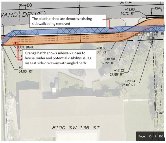
The plans are tough to read, so I asked for someone to use color to fill in the sidewalk and the planned MEGA path to provide prospective. The blue marks the existing standard size sidewalk. The color orange is used to mark where these plans have the MEGA sidewalk placed for the home at 8100 SW 136 Street. Note that for this home, the sidewalk is not a 4 foot extension of the existing, but a complete 8-10 foot new creation that is a full 10 feet or more closer to the existing home. This path is not straight, it meanders, meaning that the impact will not be the same (will not be uniform) for all the homes that front Howard Drive. Some may hardly notice it, but some homes will have a HUGE impact, you might say a MEGA impact.

Sources tell me that there is a grand Photo Op ceremony set for Friday, October 2nd (the last day of the current Interim Manager who put in notice of his resignation on Monday, September 21, but that was a prior story.)


9/22/2020 update: I have a section for the area adjacent and in front of Howard Drive Elementary School - see updated pic below:

Note how the path curves with the radius of the intersection like a sidewalk, unlike a bike lane. Does the radius at the Southwest corner of 136/77 foreshadow a future project, extending the concrete MEGA path to eventually travel South along 77th Avenue to Coral Reef Park?

Does the MEGA Path also curve into 82nd Avenue at the intersection of 136/82 and, if so, which side of 82nd Avenue will the continuation of this path travel down?

FAIR QUESTION: If this path is so great, so safe, then why did Pinecrest pay more money so this project would be pushed off, out of Pinecrest and solely onto Palmetto Bay residents?

THE TOOL BOX: CLICK HERE to view related past posts relating to the dismantaling of the bike lanes and substituting them with the Howard Drive MEGA PATH. 

Thursday, July 2, 2020

How Many Cyclists Have to Die Before We Get Serious About Bike Lanes?

I originally started this post on June 29th and put it aside. Then I learned his name, Hector Echeverria, and realized that my family knew him and his family. He was my daughter's Algebra 2 teacher at Coral Reef High and subsequently taught at Palmetto High and MAST Academy. He lived two blocks away from us, and my other daughter knew his daughter at Coral Reef Elementary, Southwood Middle School, and Palmetto Senior. She also knew Hector. He was a caring, gentle, and certainly not careless man. At 57, he had just beaten pancreatic cancer.

This is the cyclist who was mowed down by a vehicle in what was supposed to be a 25 mph street on Key Biscayne this past weekend. A second cyclist was also struck and remains in the hospital. 


I mourn the loss of another cyclist - one who had a deep and personal connection to Palmetto Bay. I still do not know the identity of the other cyclist. But regardless, a pair of cyclists were struck by a single vehicle early Sunday morning on Key Biscayne. There appears to be no allegation that either cyclist was doing anything other than what thousands of others do riding that same route. Another life lost and more lives changed forever.

But hey, keep tell me how we don’t need bike lanes. We still know little about this accident. But killing a cyclist is barely even a traffic ticket in South Florida. And there are always those who will make the point that cyclists are a nuisance -- as if they deserve the death penalty for getting in your way.

There has been much discussion and planning for bike lanes in Palmetto Bay. But there seems to be a lack of political will to act beyond planning. Politicians, including our own Daniella Levine-Cava, hold meetings. There are longstanding strategic / master / local / community plans. Plans are not the problem. The problem is that the efforts end with a celebration of discussion. Then people go back thinking there will be action, implementation. But there is little to none. And then more are injured or worse, killed. And then we all wonder why.

Or maybe discussion ends because politicians are scared of a few neighbors who don't like cyclists -- even if those cyclists are kids trying to get to school.


Why do I post my opinions here? Because this latest killing occurred at a spot where many were pushing for meaningful changes to improve safety. It tears me up to think of what this family is going through. The route was one used primarily by bikes, basically like being in a park. A road where it occurred, I am told, had a posted speed limit (for any vehicle, any type) of 25 MPH. I am familiar with this area, having ridden this route often. It is filled with bicycles.

This situation has been festering for far too long. Cycling advocates, and anyone who believes that life has value, need to ask whether this latest killing should (not could, but should) have been prevented. 

When will discussion result in actual action? We have seen many, many, “initiatives” where people are called together to discuss the issues, weigh in and propose solutions.  I have participated in some of these:  See the Miami-Dade County "Dead Serious" discussions reported back in May of 2018 (CLICK HERE to review). What has changed? Everything appeared to have gone dark once the videos and photo ops were completed. "Mission accomplished" was declared seemingly without any new protections actually put in place. 

County Commissioner Cava promised to construct bicycle lanes on 136 Street from Old Cutler to US 1. (CLICK HERE to view the full text of her transportation plan promises made back in January 2018) # 11 of the projects listed for 2018 was “11) Construct bicycle lanes on 136 Street from Old Cutler to US 1.” Instead, years later, the project was swapped out for a 8-10 foot sidewalk placed in the right of way, south side (Palmetto Bay side) of SW 136 Street). See December 29, 2019, The SW 136th Street Plans are posted for your review. Currently your only source to view as Palmetto Bay officials continue to fail to post these documents Bait, meet switch.
The above is just a single example. But the bottom line is that, as long as pedestrians (and their dogs and children) are on the path, cyclists will continue to ride along on the roadway of SW 136th Street as they are legally entitled to; where they will not be placing pedestrians at risk of bikes or be at risk of being struck by vehicles turning on or off the roadway (a recent example was posted on June 24, 2020, Yet another car v bike conflict along the Old Cutler Trail – a multi-use path, not a dedicated bike lane.)

I have worked to implement actual solutions, including safe routes to school programs, bike lanes and cyclist and motorist safety education. Implementation, going beyond the planning.  Discussion, advocating, location (and, more importantly, securing) funding and then implemented.

But it is disingenuous and worse – actually dangerous – when plans are derailed and replaced with lesser alternatives, that are not really alternatives at all, but 'repurposing' serious transportation safety issues to recreational uses that continues to place cyclists at risk. Cyclists that are our family, friends, neighbors, co-workers - teachers.  

Look at the dates of the “Dead Serious” initiatives. Where is the follow up, the delivery, a completion of a project? What has been actually implemented as a result of the efforts? Photo ops or actual efforts to improve safety? How many more need to die?

Meanwhile - Palmetto Bay continues to sit on $1 million dollars, a grant which they received to during my administration. This is that was to be used to make bicycling safer and, what's more, to enable people to use public transportation and take a bicycle for the first and last mile of public transportation. It would also help students to bicycle to Southwood Middle School. Is Palmetto Bay going to use this grant? Or should it be returned so that it can be awarded to another local government that we can trust to keep promises made. 

Fair Question: WILL PALMETTO BAY SQUANDER A $1 MILLION GRANT RECEIVED FOR ROADS?


SUPPORT VERSUS ACCOMPLISHMENTS. It is easy to wave a flag in support. The hard part is actually delivering solutions. I suggest that this current Palmetto Bay Village Council, Charter Officers and Staff take a look at policy set to date by prior administrations, specifically Resolution 2017-67,  (sponsored by then Mayor Eugene Flinn) wherein the Village Council unanimously adopted  Miami-Dade County’s “Complete Streets Guidelines” and directed that these guidelines should be incorporated into the planning, design, approval, and implementation processes for any construction, reconstruction, retrofit, maintenance, alteration, or repair of streets, bridges, or other portions of the transportation network, including pavement resurfacing, restriping, and signalization operations if the safety and convenience of all types of users (i.e., pedestrians, bicyclists, motorists, and public transit riders, including children, youth, families, older adults, and individuals with disabilities) can be improved within the scope of the work.

CONCLUDING STATEMENT:  I make no apologies for the passion and venting of frustration. People are dying - all types - parents, grandparents, sons, daughters, friends and neighbors. Yes, some are sportsters; but many of these victims were simply traveling on a short commute by bike to or from work, riding to school or a friends house, or otherwise simply on a leisurely ride, but all were in the very wrong place at a very wrong time.  So spare me the celebration of yet another public photo op forum. I am demanding implementation, that promises be kept.